You are here: Home > Network List > AK - Alaska Regional Network Stations List
> Station H23K Yukon River, AK, USA > Earthquake Result Viewer
H23K Yukon River, AK, USA - Earthquake Result Viewer
| Earthquake location: |
Mariana Islands Region |
| Earthquake latitude/longitude: |
18.8/147.0 |
| Earthquake time(UTC): |
2022/07/10 (191) 22:19:59 GMT |
| Earthquake Depth: |
10 km |
| Earthquake Magnitude: |
5.6 mww |
| Earthquake Catalog/Contributor: |
NEIC PDE/us |
|
| Network: |
AK Alaska Regional Network |
| Station: |
H23K Yukon River, AK, USA |
| Lat/Lon: |
65.83 N/149.54 W |
| Elevation: |
617 m |
|
| Distance: |
62.2 deg |
| Az: |
24.598 deg |
| Baz: |
253.267 deg |
| Ray Param: |
0.060376786 |
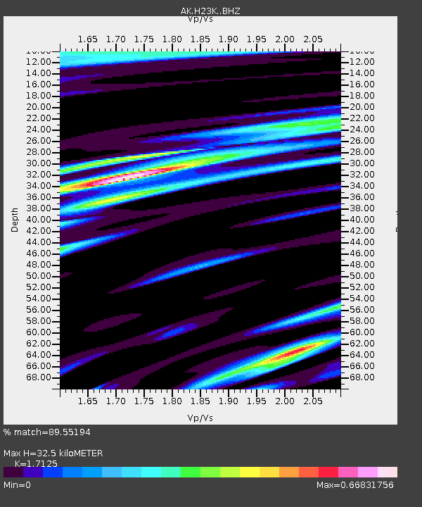
| Estimated Moho Depth: |
32.5 km |
| Estimated Crust Vp/Vs: |
1.71 |
| Assumed Crust Vp: |
6.566 km/s |
| Estimated Crust Vs: |
3.834 km/s |
| Estimated Crust Poisson's Ratio: |
0.24 |
|
| Radial Match: |
89.55194 % |
| Radial Bump: |
376 |
| Transverse Match: |
82.81668 % |
| Transverse Bump: |
400 |
| SOD ConfigId: |
28208852 |
| Insert Time: |
2022-07-24 22:23:31.334 +0000 |
| GWidth: |
2.5 |
| Max Bumps: |
400 |
| Tol: |
0.001 |
|

Signal To Noise
| Channel | StoN | STA | LTA |
| AK:H23K: :BHZ:20220710T22:29:49.759998Z | 15.0669155 | 7.2127824E-7 | 4.787166E-8 |
| AK:H23K: :BHN:20220710T22:29:49.759998Z | 2.5449834 | 1.6191046E-7 | 6.361945E-8 |
| AK:H23K: :BHE:20220710T22:29:49.759998Z | 7.5712385 | 3.0108546E-7 | 3.9767002E-8 |
| Arrivals |
| Ps | 3.7 SECOND |
| PpPs | 13 SECOND |
| PsPs/PpSs | 16 SECOND |


