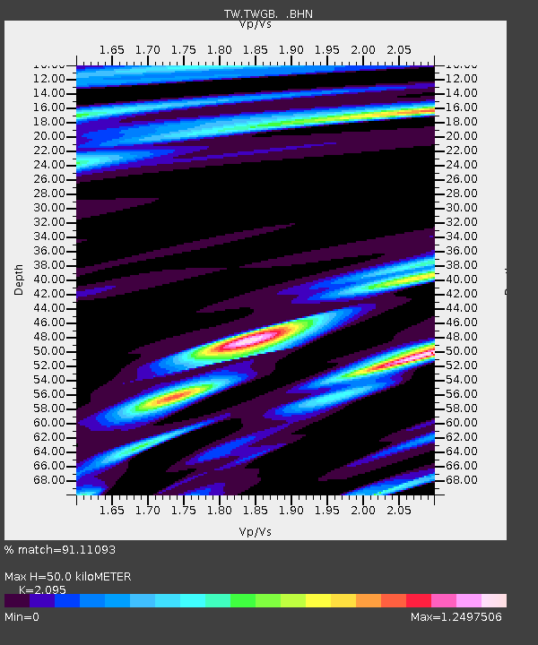
TWGB TAI-TUNG - Earthquake Result Viewer

Earthquake location: Kuril Islands
Earthquake latitude/longitude: 44.3/148.4
Earthquake time(UTC): 2001/05/25 (145) 00:40:50 GMT
Earthquake Depth: 33 km
Earthquake Magnitude: 6.1 MB, 6.7 MS, 6.7 MW, 6.6 MW
Earthquake Catalog/Contributor: WHDF/NEIC
Network: TW Broadband Array in Taiwan for Seismology
Station: TWGB TAI-TUNG
Lat/Lon: 22.82 N/121.08 E
Elevation: 195 m
Distance: 31.0 deg
Az: 235.292 deg
Baz: 39.798 deg
Ray Param: 0.07915403
Estimated Moho Depth: 50.0 km
Estimated Crust Vp/Vs: 2.10
Assumed Crust Vp: 6.461 km/s
Estimated Crust Vs: 3.084 km/s
Estimated Crust Poisson's Ratio: 0.35
Radial Match: 91.11093 %
Radial Bump: 400
Transverse Match: 82.56874 %
Transverse Bump: 400
SOD ConfigId: 4714
Insert Time: 2010-03-09 22:07:47.183 +0000
GWidth: 2.5
Max Bumps: 400
Tol: 0.001

Signal To Noise

ChannelStoNSTALTA
TW:TWGB: :BHN:20010525T00:46:34.712Z4.42992971.3071433E-62.950709E-7
TW:TWGB: :BHE:20010525T00:46:34.712Z4.82719331.0857331E-62.2492016E-7
TW:TWGB: :BHZ:20010525T00:46:34.712Z10.5743962.1474286E-62.0307813E-7
Arrivals
Ps9.1 SECOND
PpPs22 SECOND
PsPs/PpSs31 SECOND