You are here: Home > Network List > TW - Broadband Array in Taiwan for Seismology Stations List
> Station TWGB TAI-TUNG > Earthquake Result Viewer
TWGB TAI-TUNG - Earthquake Result Viewer
| Earthquake location: |
Java, Indonesia |
| Earthquake latitude/longitude: |
-7.9/110.2 |
| Earthquake time(UTC): |
2001/05/25 (145) 05:06:10 GMT |
| Earthquake Depth: |
143 km |
| Earthquake Magnitude: |
5.8 MB, 6.3 MW, 6.3 MW |
| Earthquake Catalog/Contributor: |
WHDF/NEIC |
|
| Network: |
TW Broadband Array in Taiwan for Seismology |
| Station: |
TWGB TAI-TUNG |
| Lat/Lon: |
22.82 N/121.08 E |
| Elevation: |
195 m |
|
| Distance: |
32.3 deg |
| Az: |
19.053 deg |
| Baz: |
200.519 deg |
| Ray Param: |
0.078290515 |
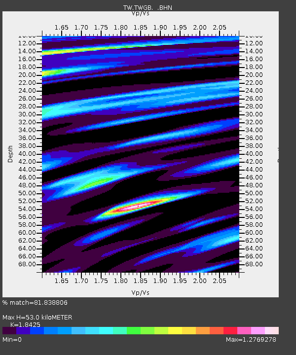
| Estimated Moho Depth: |
53.0 km |
| Estimated Crust Vp/Vs: |
1.84 |
| Assumed Crust Vp: |
6.461 km/s |
| Estimated Crust Vs: |
3.507 km/s |
| Estimated Crust Poisson's Ratio: |
0.29 |
|
| Radial Match: |
81.838806 % |
| Radial Bump: |
400 |
| Transverse Match: |
71.440094 % |
| Transverse Bump: |
400 |
| SOD ConfigId: |
4714 |
| Insert Time: |
2010-03-09 22:07:49.101 +0000 |
| GWidth: |
2.5 |
| Max Bumps: |
400 |
| Tol: |
0.001 |
|

Signal To Noise
| Channel | StoN | STA | LTA |
| TW:TWGB: :BHN:20010525T05:11:55.862007Z | 4.4544954 | 9.07921E-7 | 2.038213E-7 |
| TW:TWGB: :BHE:20010525T05:11:55.862007Z | 1.3751764 | 3.630823E-7 | 2.6402597E-7 |
| TW:TWGB: :BHZ:20010525T05:11:55.862007Z | 8.311998 | 1.915556E-6 | 2.3045672E-7 |
| Arrivals |
| Ps | 7.5 SECOND |
| PpPs | 22 SECOND |
| PsPs/PpSs | 29 SECOND |


