You are here: Home > Network List > TW - Broadband Array in Taiwan for Seismology Stations List
> Station TWGB TAI-TUNG > Earthquake Result Viewer
TWGB TAI-TUNG - Earthquake Result Viewer
| Earthquake location: |
New Britain Region, P.N.G. |
| Earthquake latitude/longitude: |
-5.7/149.5 |
| Earthquake time(UTC): |
2009/05/12 (132) 01:26:26 GMT |
| Earthquake Depth: |
84 km |
| Earthquake Magnitude: |
5.9 MB, 6.1 MW, 6.1 MW |
| Earthquake Catalog/Contributor: |
WHDF/NEIC |
|
| Network: |
TW Broadband Array in Taiwan for Seismology |
| Station: |
TWGB TAI-TUNG |
| Lat/Lon: |
22.82 N/121.08 E |
| Elevation: |
195 m |
|
| Distance: |
39.7 deg |
| Az: |
316.485 deg |
| Baz: |
132.04 deg |
| Ray Param: |
0.07455932 |
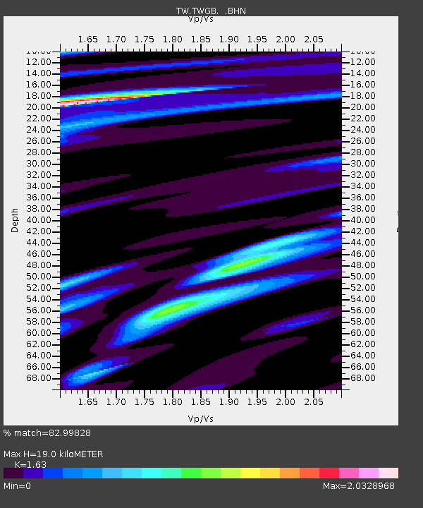
| Estimated Moho Depth: |
19.0 km |
| Estimated Crust Vp/Vs: |
1.63 |
| Assumed Crust Vp: |
6.461 km/s |
| Estimated Crust Vs: |
3.964 km/s |
| Estimated Crust Poisson's Ratio: |
0.20 |
|
| Radial Match: |
82.99828 % |
| Radial Bump: |
400 |
| Transverse Match: |
66.925415 % |
| Transverse Bump: |
400 |
| SOD ConfigId: |
2760 |
| Insert Time: |
2010-03-09 22:08:04.614 +0000 |
| GWidth: |
2.5 |
| Max Bumps: |
400 |
| Tol: |
0.001 |
|

Signal To Noise
| Channel | StoN | STA | LTA |
| TW:TWGB: :BHN:20090512T01:33:19.669009Z | 7.6719117 | 4.2355996E-6 | 5.520918E-7 |
| TW:TWGB: :BHE:20090512T01:33:19.669009Z | 2.8157625 | 2.0399818E-6 | 7.244865E-7 |
| TW:TWGB: :BHZ:20090512T01:33:19.669009Z | 3.0355856 | 2.0178102E-6 | 6.647186E-7 |
| Arrivals |
| Ps | 2.0 SECOND |
| PpPs | 7.2 SECOND |
| PsPs/PpSs | 9.2 SECOND |


