You are here: Home > Network List > AV - Alaska Volcano Observatory Stations List
> Station MNAT Nateekin Bay, Makushin Volcano, Alaska > Earthquake Result Viewer
MNAT Nateekin Bay, Makushin Volcano, Alaska - Earthquake Result Viewer
| Earthquake location: |
Mariana Islands Region |
| Earthquake latitude/longitude: |
18.8/147.0 |
| Earthquake time(UTC): |
2022/07/10 (191) 22:19:59 GMT |
| Earthquake Depth: |
10 km |
| Earthquake Magnitude: |
5.6 mww |
| Earthquake Catalog/Contributor: |
NEIC PDE/us |
|
| Network: |
AV Alaska Volcano Observatory |
| Station: |
MNAT Nateekin Bay, Makushin Volcano, Alaska |
| Lat/Lon: |
53.88 N/166.69 W |
| Elevation: |
390 m |
|
| Distance: |
49.8 deg |
| Az: |
34.065 deg |
| Baz: |
243.691 deg |
| Ray Param: |
0.06848801 |
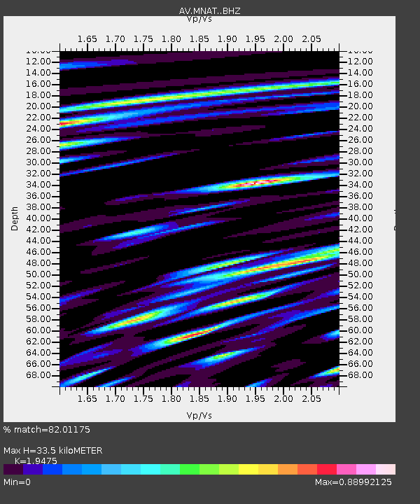
| Estimated Moho Depth: |
33.5 km |
| Estimated Crust Vp/Vs: |
1.95 |
| Assumed Crust Vp: |
3.943 km/s |
| Estimated Crust Vs: |
2.025 km/s |
| Estimated Crust Poisson's Ratio: |
0.32 |
|
| Radial Match: |
82.01175 % |
| Radial Bump: |
400 |
| Transverse Match: |
68.47641 % |
| Transverse Bump: |
400 |
| SOD ConfigId: |
28208852 |
| Insert Time: |
2022-07-24 22:28:58.406 +0000 |
| GWidth: |
2.5 |
| Max Bumps: |
400 |
| Tol: |
0.001 |
|
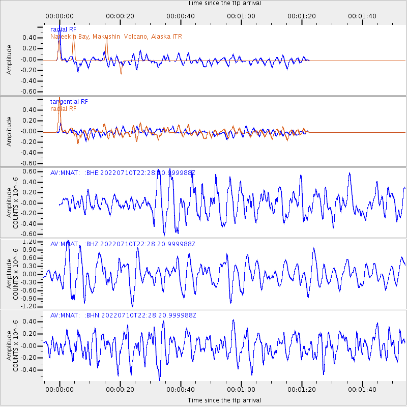
Signal To Noise
| Channel | StoN | STA | LTA |
| AV:MNAT: :BHZ:20220710T22:28:20.999988Z | 8.373218 | 6.552632E-7 | 7.825704E-8 |
| AV:MNAT: :BHN:20220710T22:28:20.999988Z | 1.3937405 | 1.3094763E-7 | 9.395409E-8 |
| AV:MNAT: :BHE:20220710T22:28:20.999988Z | 3.6488945 | 3.5560385E-7 | 9.745523E-8 |
| Arrivals |
| Ps | 8.2 SECOND |
| PpPs | 25 SECOND |
| PsPs/PpSs | 33 SECOND |


