You are here: Home > Network List > AV - Alaska Volcano Observatory Stations List
> Station P19K Oil Pt, AK, USA > Earthquake Result Viewer
P19K Oil Pt, AK, USA - Earthquake Result Viewer
| Earthquake location: |
Mariana Islands Region |
| Earthquake latitude/longitude: |
18.8/147.0 |
| Earthquake time(UTC): |
2022/07/10 (191) 22:19:59 GMT |
| Earthquake Depth: |
10 km |
| Earthquake Magnitude: |
5.6 mww |
| Earthquake Catalog/Contributor: |
NEIC PDE/us |
|
| Network: |
AV Alaska Volcano Observatory |
| Station: |
P19K Oil Pt, AK, USA |
| Lat/Lon: |
59.65 N/153.23 W |
| Elevation: |
629 m |
|
| Distance: |
58.8 deg |
| Az: |
30.843 deg |
| Baz: |
253.066 deg |
| Ray Param: |
0.062611386 |
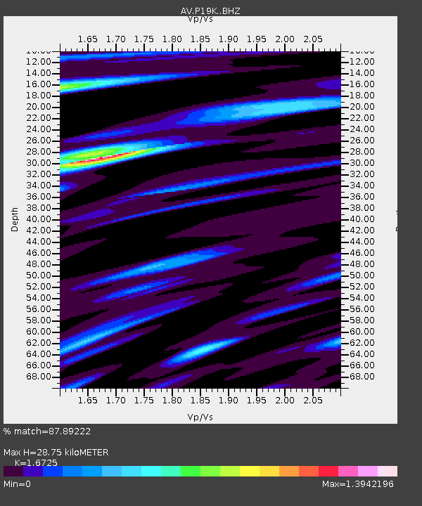
| Estimated Moho Depth: |
28.75 km |
| Estimated Crust Vp/Vs: |
1.67 |
| Assumed Crust Vp: |
5.989 km/s |
| Estimated Crust Vs: |
3.581 km/s |
| Estimated Crust Poisson's Ratio: |
0.22 |
|
| Radial Match: |
87.89222 % |
| Radial Bump: |
400 |
| Transverse Match: |
85.06635 % |
| Transverse Bump: |
400 |
| SOD ConfigId: |
28208852 |
| Insert Time: |
2022-07-24 22:29:12.229 +0000 |
| GWidth: |
2.5 |
| Max Bumps: |
400 |
| Tol: |
0.001 |
|

Signal To Noise
| Channel | StoN | STA | LTA |
| AV:P19K: :BHZ:20220710T22:29:26.424976Z | 9.368337 | 9.93237E-7 | 1.0602063E-7 |
| AV:P19K: :BHN:20220710T22:29:26.424976Z | 2.5476422 | 2.6569825E-7 | 1.0429182E-7 |
| AV:P19K: :BHE:20220710T22:29:26.424976Z | 2.7304342 | 3.3270004E-7 | 1.2184877E-7 |
| Arrivals |
| Ps | 3.4 SECOND |
| PpPs | 12 SECOND |
| PsPs/PpSs | 16 SECOND |


