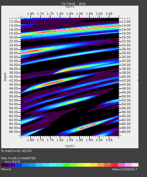
TWGB TAI-TUNG - Earthquake Result Viewer

Earthquake location: South Of Java, Indonesia
Earthquake latitude/longitude: -10.5/108.1
Earthquake time(UTC): 2007/06/26 (177) 22:23:03 GMT
Earthquake Depth: 10 km
Earthquake Magnitude: 5.8 MB, 5.6 MS, 6.0 MW, 5.9 MW
Earthquake Catalog/Contributor: WHDF/NEIC
Network: TW Broadband Array in Taiwan for Seismology
Station: TWGB TAI-TUNG
Lat/Lon: 22.82 N/121.08 E
Elevation: 195 m
Distance: 35.4 deg
Az: 20.857 deg
Baz: 202.303 deg
Ray Param: 0.07721974
Estimated Moho Depth: 65.0 km
Estimated Crust Vp/Vs: 1.94
Assumed Crust Vp: 6.461 km/s
Estimated Crust Vs: 3.335 km/s
Estimated Crust Poisson's Ratio: 0.32
Radial Match: 81.90334 %
Radial Bump: 400
Transverse Match: 59.805614 %
Transverse Bump: 400
SOD ConfigId: 2564
Insert Time: 2010-03-09 22:08:22.428 +0000
GWidth: 2.5
Max Bumps: 400
Tol: 0.001

Signal To Noise

ChannelStoNSTALTA
TW:TWGB: :BHN:20070626T22:29:28.592002Z2.04677183.27259E-71.5989032E-7
TW:TWGB: :BHE:20070626T22:29:28.592002Z1.63385512.2331149E-71.3667766E-7
TW:TWGB: :BHZ:20070626T22:29:28.592002Z3.54639745.760001E-71.6241837E-7
Arrivals
Ps10 SECOND
PpPs28 SECOND
PsPs/PpSs38 SECOND