You are here: Home > Network List > AV - Alaska Volcano Observatory Stations List
> Station SPBL Spurr Beluga Lake, Mount Spur, Alaska > Earthquake Result Viewer
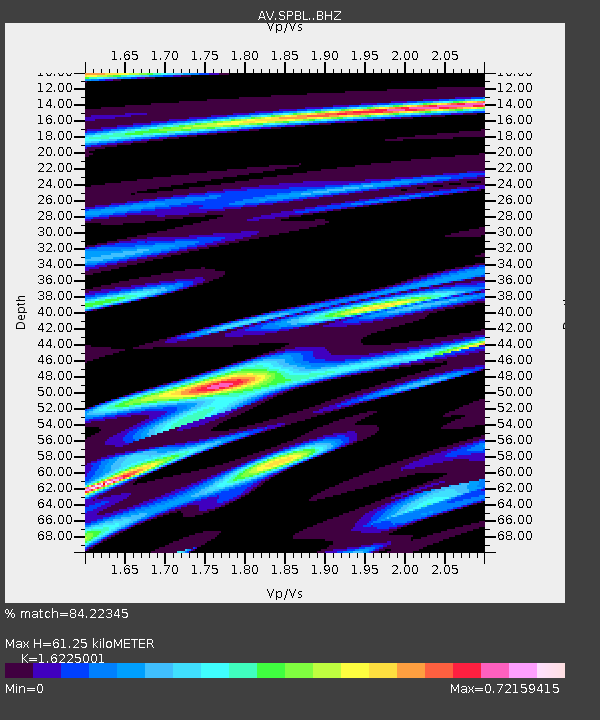
SPBL Spurr Beluga Lake, Mount Spur, Alaska - Earthquake Result Viewer
| Earthquake location: |
Mariana Islands Region |
| Earthquake latitude/longitude: |
18.8/147.0 |
| Earthquake time(UTC): |
2022/07/10 (191) 22:19:59 GMT |
| Earthquake Depth: |
10 km |
| Earthquake Magnitude: |
5.6 mww |
| Earthquake Catalog/Contributor: |
NEIC PDE/us |
|
| Network: |
AV Alaska Volcano Observatory |
| Station: |
SPBL Spurr Beluga Lake, Mount Spur, Alaska |
| Lat/Lon: |
61.38 N/151.89 W |
| Elevation: |
927 m |
|
| Distance: |
59.9 deg |
| Az: |
29.141 deg |
| Baz: |
253.36 deg |
| Ray Param: |
0.06186478 |
| Estimated Moho Depth: |
61.25 km |
| Estimated Crust Vp/Vs: |
1.62 |
| Assumed Crust Vp: |
6.302 km/s |
| Estimated Crust Vs: |
3.884 km/s |
| Estimated Crust Poisson's Ratio: |
0.19 |
|
| Radial Match: |
84.22345 % |
| Radial Bump: |
400 |
| Transverse Match: |
71.92805 % |
| Transverse Bump: |
400 |
| SOD ConfigId: |
28208852 |
| Insert Time: |
2022-07-24 22:29:35.807 +0000 |
| GWidth: |
2.5 |
| Max Bumps: |
400 |
| Tol: |
0.001 |
|

Signal To Noise
| Channel | StoN | STA | LTA |
| AV:SPBL: :BHZ:20220710T22:29:34.239979Z | 16.183348 | 7.175242E-7 | 4.433719E-8 |
| AV:SPBL: :BHN:20220710T22:29:34.239979Z | 3.0958807 | 2.3055728E-7 | 7.4472275E-8 |
| AV:SPBL: :BHE:20220710T22:29:34.239979Z | 3.129572 | 1.695299E-7 | 5.4170314E-8 |
| Arrivals |
| Ps | 6.4 SECOND |
| PpPs | 24 SECOND |
| PsPs/PpSs | 31 SECOND |


