You are here: Home > Network List > AV - Alaska Volcano Observatory Stations List
> Station SPCR Ckakachatna River, Mount Spurr, Alaska > Earthquake Result Viewer
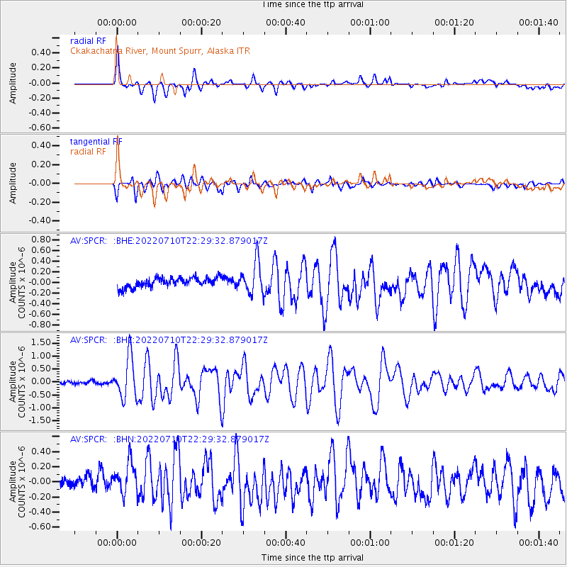
SPCR Ckakachatna River, Mount Spurr, Alaska - Earthquake Result Viewer

| Earthquake location: |
Mariana Islands Region |
| Earthquake latitude/longitude: |
18.8/147.0 |
| Earthquake time(UTC): |
2022/07/10 (191) 22:19:59 GMT |
| Earthquake Depth: |
10 km |
| Earthquake Magnitude: |
5.6 mww |
| Earthquake Catalog/Contributor: |
NEIC PDE/us |
|
| Network: |
AV Alaska Volcano Observatory |
| Station: |
SPCR Ckakachatna River, Mount Spurr, Alaska |
| Lat/Lon: |
61.20 N/152.21 W |
| Elevation: |
984 m |
|
| Distance: |
59.7 deg |
| Az: |
29.286 deg |
| Baz: |
253.158 deg |
| Ray Param: |
0.061997358 |
| Estimated Moho Depth: |
60.25 km |
| Estimated Crust Vp/Vs: |
2.10 |
| Assumed Crust Vp: |
6.566 km/s |
| Estimated Crust Vs: |
3.13 km/s |
| Estimated Crust Poisson's Ratio: |
0.35 |
|
| Radial Match: |
83.712425 % |
| Radial Bump: |
400 |
| Transverse Match: |
84.05538 % |
| Transverse Bump: |
400 |
| SOD ConfigId: |
28208852 |
| Insert Time: |
2022-07-24 22:29:41.429 +0000 |
| GWidth: |
2.5 |
| Max Bumps: |
400 |
| Tol: |
0.001 |
|
Signal To Noise
| Channel | StoN | STA | LTA |
| AV:SPCR: :BHZ:20220710T22:29:32.879017Z | 13.546826 | 8.213286E-7 | 6.062886E-8 |
| AV:SPCR: :BHN:20220710T22:29:32.879017Z | 2.6417449 | 2.1432413E-7 | 8.112976E-8 |
| AV:SPCR: :BHE:20220710T22:29:32.879017Z | 3.4235454 | 3.1553228E-7 | 9.216536E-8 |
| Arrivals |
| Ps | 10 SECOND |
| PpPs | 27 SECOND |
| PsPs/PpSs | 38 SECOND |


