You are here: Home > Network List > C0 - Colorado Geological Survey Seismic Network Stations List
> Station N23A Red Feather Lakes, CO > Earthquake Result Viewer
N23A Red Feather Lakes, CO - Earthquake Result Viewer
| Earthquake location: |
Mariana Islands Region |
| Earthquake latitude/longitude: |
18.8/147.0 |
| Earthquake time(UTC): |
2022/07/10 (191) 22:19:59 GMT |
| Earthquake Depth: |
10 km |
| Earthquake Magnitude: |
5.6 mww |
| Earthquake Catalog/Contributor: |
NEIC PDE/us |
|
| Network: |
C0 Colorado Geological Survey Seismic Network |
| Station: |
N23A Red Feather Lakes, CO |
| Lat/Lon: |
40.89 N/105.94 W |
| Elevation: |
2452 m |
|
| Distance: |
90.1 deg |
| Az: |
46.462 deg |
| Baz: |
295.039 deg |
| Ray Param: |
0.04172278 |
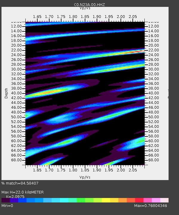
| Estimated Moho Depth: |
22.0 km |
| Estimated Crust Vp/Vs: |
2.10 |
| Assumed Crust Vp: |
6.306 km/s |
| Estimated Crust Vs: |
3.006 km/s |
| Estimated Crust Poisson's Ratio: |
0.35 |
|
| Radial Match: |
84.58407 % |
| Radial Bump: |
400 |
| Transverse Match: |
77.0214 % |
| Transverse Bump: |
400 |
| SOD ConfigId: |
28208852 |
| Insert Time: |
2022-07-24 22:31:43.544 +0000 |
| GWidth: |
2.5 |
| Max Bumps: |
400 |
| Tol: |
0.001 |
|

Signal To Noise
| Channel | StoN | STA | LTA |
| C0:N23A:00:HHZ:20220710T22:32:27.609974Z | 11.762775 | 6.9005733E-7 | 5.8664497E-8 |
| C0:N23A:00:HHN:20220710T22:32:27.609974Z | 0.7502968 | 1.2655822E-7 | 1.6867754E-7 |
| C0:N23A:00:HHE:20220710T22:32:27.609974Z | 2.7612617 | 2.1316897E-7 | 7.719984E-8 |
| Arrivals |
| Ps | 3.9 SECOND |
| PpPs | 11 SECOND |
| PsPs/PpSs | 15 SECOND |


