You are here: Home > Network List > XM99 - Rio Grande Seismic Transect Stations List
> Station MB01 Magmabody01 > Earthquake Result Viewer
MB01 Magmabody01 - Earthquake Result Viewer
| Earthquake location: |
Fiji Islands Region |
| Earthquake latitude/longitude: |
-18.1/-176.9 |
| Earthquake time(UTC): |
2001/04/28 (118) 04:49:53 GMT |
| Earthquake Depth: |
352 km |
| Earthquake Magnitude: |
6.2 MB, 6.8 MW, 6.8 MW |
| Earthquake Catalog/Contributor: |
WHDF/NEIC |
|
| Network: |
XM Rio Grande Seismic Transect |
| Station: |
MB01 Magmabody01 |
| Lat/Lon: |
33.34 N/106.03 W |
| Elevation: |
1446 m |
|
| Distance: |
84.7 deg |
| Az: |
52.603 deg |
| Baz: |
244.528 deg |
| Ray Param: |
0.04436364 |
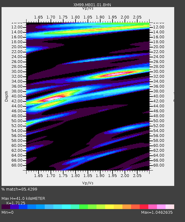
| Estimated Moho Depth: |
41.0 km |
| Estimated Crust Vp/Vs: |
1.71 |
| Assumed Crust Vp: |
6.502 km/s |
| Estimated Crust Vs: |
3.797 km/s |
| Estimated Crust Poisson's Ratio: |
0.24 |
|
| Radial Match: |
85.4299 % |
| Radial Bump: |
400 |
| Transverse Match: |
64.00933 % |
| Transverse Bump: |
400 |
| SOD ConfigId: |
4714 |
| Insert Time: |
2010-02-26 17:33:06.397 +0000 |
| GWidth: |
2.5 |
| Max Bumps: |
400 |
| Tol: |
0.001 |
|

Signal To Noise
| Channel | StoN | STA | LTA |
| XM:MB01:01:BHN:20010428T05:01:17.432014Z | 0.7078399 | 7.6199086E-8 | 1.0765017E-7 |
| XM:MB01:01:BHE:20010428T05:01:17.432014Z | 2.0744853 | 2.0911264E-7 | 1.00802175E-7 |
| XM:MB01:01:BHZ:20010428T05:01:17.432014Z | 7.469739 | 8.779468E-7 | 1.175338E-7 |
| Arrivals |
| Ps | 4.6 SECOND |
| PpPs | 17 SECOND |
| PsPs/PpSs | 21 SECOND |


