You are here: Home > Network List > UU - University of Utah Regional Network Stations List
> Station SVWY Solvay Mine, WY, USA > Earthquake Result Viewer
SVWY Solvay Mine, WY, USA - Earthquake Result Viewer
| Earthquake location: |
Fiji Islands Region |
| Earthquake latitude/longitude: |
-18.2/-178.1 |
| Earthquake time(UTC): |
2018/08/19 (231) 00:19:37 GMT |
| Earthquake Depth: |
563 km |
| Earthquake Magnitude: |
8.2 mww |
| Earthquake Catalog/Contributor: |
NEIC PDE/us |
|
| Network: |
UU University of Utah Regional Network |
| Station: |
SVWY Solvay Mine, WY, USA |
| Lat/Lon: |
41.45 N/109.86 W |
| Elevation: |
1950 m |
|
| Distance: |
86.5 deg |
| Az: |
44.385 deg |
| Baz: |
242.205 deg |
| Ray Param: |
0.042370778 |
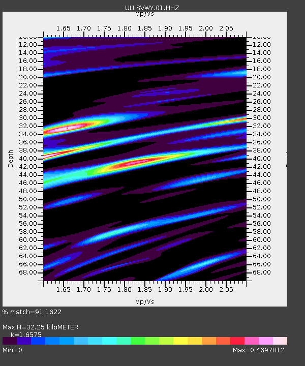
| Estimated Moho Depth: |
32.25 km |
| Estimated Crust Vp/Vs: |
1.66 |
| Assumed Crust Vp: |
6.207 km/s |
| Estimated Crust Vs: |
3.745 km/s |
| Estimated Crust Poisson's Ratio: |
0.21 |
|
| Radial Match: |
91.1622 % |
| Radial Bump: |
400 |
| Transverse Match: |
92.61413 % |
| Transverse Bump: |
400 |
| SOD ConfigId: |
2825771 |
| Insert Time: |
2018-09-02 01:45:42.617 +0000 |
| GWidth: |
2.5 |
| Max Bumps: |
400 |
| Tol: |
0.001 |
|

Signal To Noise
| Channel | StoN | STA | LTA |
| UU:SVWY:01:HHZ:20180819T00:30:50.410002Z | 19.255775 | 7.901241E-8 | 4.1033097E-9 |
| UU:SVWY:01:HHN:20180819T00:30:50.410002Z | 1.9772207 | 6.6577837E-9 | 3.3672436E-9 |
| UU:SVWY:01:HHE:20180819T00:30:50.410002Z | 4.7905765 | 1.7902043E-8 | 3.7369285E-9 |
| Arrivals |
| Ps | 3.5 SECOND |
| PpPs | 14 SECOND |
| PsPs/PpSs | 17 SECOND |


