You are here: Home > Network List > GS - US Geological Survey Networks Stations List
> Station MCA04 MCA04, Monte Cristo Range, NV > Earthquake Result Viewer
MCA04 MCA04, Monte Cristo Range, NV - Earthquake Result Viewer
| Earthquake location: |
Mariana Islands Region |
| Earthquake latitude/longitude: |
18.8/147.0 |
| Earthquake time(UTC): |
2022/07/10 (191) 22:19:59 GMT |
| Earthquake Depth: |
10 km |
| Earthquake Magnitude: |
5.6 mww |
| Earthquake Catalog/Contributor: |
NEIC PDE/us |
|
| Network: |
GS US Geological Survey Networks |
| Station: |
MCA04 MCA04, Monte Cristo Range, NV |
| Lat/Lon: |
38.08 N/117.71 W |
| Elevation: |
1662 m |
|
| Distance: |
82.6 deg |
| Az: |
52.412 deg |
| Baz: |
287.949 deg |
| Ray Param: |
0.04675137 |
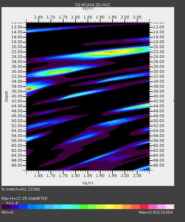
| Estimated Moho Depth: |
37.25 km |
| Estimated Crust Vp/Vs: |
1.60 |
| Assumed Crust Vp: |
6.276 km/s |
| Estimated Crust Vs: |
3.922 km/s |
| Estimated Crust Poisson's Ratio: |
0.18 |
|
| Radial Match: |
82.23386 % |
| Radial Bump: |
400 |
| Transverse Match: |
79.02591 % |
| Transverse Bump: |
337 |
| SOD ConfigId: |
28208852 |
| Insert Time: |
2022-07-24 22:38:31.419 +0000 |
| GWidth: |
2.5 |
| Max Bumps: |
400 |
| Tol: |
0.001 |
|

Signal To Noise
| Channel | StoN | STA | LTA |
| GS:MCA04:00:HHZ:20220710T22:31:51.16399Z | 9.871473 | 5.862877E-7 | 5.9392114E-8 |
| GS:MCA04:00:HH1:20220710T22:31:51.16399Z | 1.5668026 | 1.0879318E-7 | 6.9436425E-8 |
| GS:MCA04:00:HH2:20220710T22:31:51.16399Z | 3.2170677 | 1.8246652E-7 | 5.6718275E-8 |
| Arrivals |
| Ps | 3.7 SECOND |
| PpPs | 15 SECOND |
| PsPs/PpSs | 19 SECOND |


