You are here: Home > Network List > TD - TransAlta Monitoring Network Stations List
> Station TD008 Z > Earthquake Result Viewer
TD008 Z - Earthquake Result Viewer
| Earthquake location: |
Mariana Islands Region |
| Earthquake latitude/longitude: |
18.8/147.0 |
| Earthquake time(UTC): |
2022/07/10 (191) 22:19:59 GMT |
| Earthquake Depth: |
10 km |
| Earthquake Magnitude: |
5.6 mww |
| Earthquake Catalog/Contributor: |
NEIC PDE/us |
|
| Network: |
TD TransAlta Monitoring Network |
| Station: |
TD008 Z |
| Lat/Lon: |
52.80 N/115.43 W |
| Elevation: |
964 m |
|
| Distance: |
79.7 deg |
| Az: |
37.717 deg |
| Baz: |
287.31 deg |
| Ray Param: |
0.04878555 |
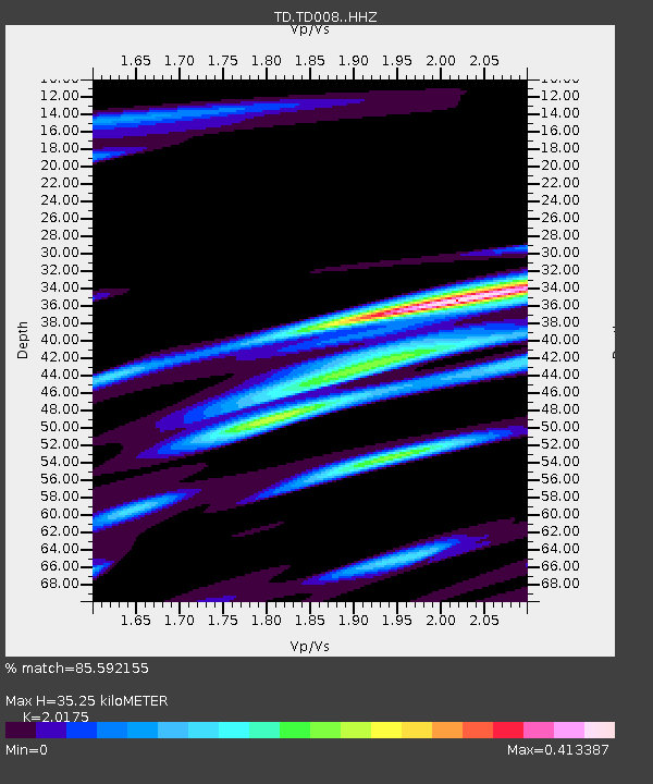
| Estimated Moho Depth: |
35.25 km |
| Estimated Crust Vp/Vs: |
2.02 |
| Assumed Crust Vp: |
6.426 km/s |
| Estimated Crust Vs: |
3.185 km/s |
| Estimated Crust Poisson's Ratio: |
0.34 |
|
| Radial Match: |
85.592155 % |
| Radial Bump: |
374 |
| Transverse Match: |
70.32378 % |
| Transverse Bump: |
398 |
| SOD ConfigId: |
28208852 |
| Insert Time: |
2022-07-24 22:45:43.226 +0000 |
| GWidth: |
2.5 |
| Max Bumps: |
400 |
| Tol: |
0.001 |
|

Signal To Noise
| Channel | StoN | STA | LTA |
| TD:TD008: :HHZ:20220710T22:31:35.559986Z | 7.4109507 | 1.0377514E-6 | 1.4002947E-7 |
| TD:TD008: :HH1:20220710T22:31:35.559986Z | 1.069901 | 1.6288847E-7 | 1.5224632E-7 |
| TD:TD008: :HH2:20220710T22:31:35.559986Z | 2.6695883 | 3.4396479E-7 | 1.2884564E-7 |
| Arrivals |
| Ps | 5.7 SECOND |
| PpPs | 16 SECOND |
| PsPs/PpSs | 22 SECOND |


