You are here: Home > Network List > UW - Pacific Northwest Regional Seismic Network Stations List
> Station FISH2 Jewell, OR, USA > Earthquake Result Viewer
FISH2 Jewell, OR, USA - Earthquake Result Viewer
| Earthquake location: |
Mariana Islands Region |
| Earthquake latitude/longitude: |
18.8/147.0 |
| Earthquake time(UTC): |
2022/07/10 (191) 22:19:59 GMT |
| Earthquake Depth: |
10 km |
| Earthquake Magnitude: |
5.6 mww |
| Earthquake Catalog/Contributor: |
NEIC PDE/us |
|
| Network: |
UW Pacific Northwest Regional Seismic Network |
| Station: |
FISH2 Jewell, OR, USA |
| Lat/Lon: |
45.93 N/123.50 W |
| Elevation: |
146 m |
|
| Distance: |
76.4 deg |
| Az: |
45.899 deg |
| Baz: |
282.889 deg |
| Ray Param: |
0.051036637 |
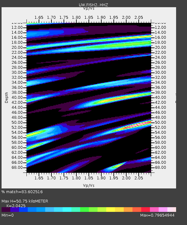
| Estimated Moho Depth: |
50.75 km |
| Estimated Crust Vp/Vs: |
2.04 |
| Assumed Crust Vp: |
6.566 km/s |
| Estimated Crust Vs: |
3.215 km/s |
| Estimated Crust Poisson's Ratio: |
0.34 |
|
| Radial Match: |
83.602516 % |
| Radial Bump: |
398 |
| Transverse Match: |
75.33868 % |
| Transverse Bump: |
400 |
| SOD ConfigId: |
28208852 |
| Insert Time: |
2022-07-24 22:49:43.089 +0000 |
| GWidth: |
2.5 |
| Max Bumps: |
400 |
| Tol: |
0.001 |
|

Signal To Noise
| Channel | StoN | STA | LTA |
| UW:FISH2: :HHZ:20220710T22:31:17.249988Z | 9.287512 | 7.628431E-7 | 8.213644E-8 |
| UW:FISH2: :HHN:20220710T22:31:17.249988Z | 1.0116533 | 1.3911004E-7 | 1.3750763E-7 |
| UW:FISH2: :HHE:20220710T22:31:17.249988Z | 2.5306673 | 2.2673201E-7 | 8.959377E-8 |
| Arrivals |
| Ps | 8.3 SECOND |
| PpPs | 23 SECOND |
| PsPs/PpSs | 31 SECOND |


