You are here: Home > Network List > UW - Pacific Northwest Regional Seismic Network Stations List
> Station MOODY Moody Rd Farm, Hoquiam, WA, USA > Earthquake Result Viewer
MOODY Moody Rd Farm, Hoquiam, WA, USA - Earthquake Result Viewer
| Earthquake location: |
Mariana Islands Region |
| Earthquake latitude/longitude: |
18.8/147.0 |
| Earthquake time(UTC): |
2022/07/10 (191) 22:19:59 GMT |
| Earthquake Depth: |
10 km |
| Earthquake Magnitude: |
5.6 mww |
| Earthquake Catalog/Contributor: |
NEIC PDE/us |
|
| Network: |
UW Pacific Northwest Regional Seismic Network |
| Station: |
MOODY Moody Rd Farm, Hoquiam, WA, USA |
| Lat/Lon: |
47.21 N/124.01 W |
| Elevation: |
33 m |
|
| Distance: |
75.8 deg |
| Az: |
44.69 deg |
| Baz: |
282.225 deg |
| Ray Param: |
0.051457405 |
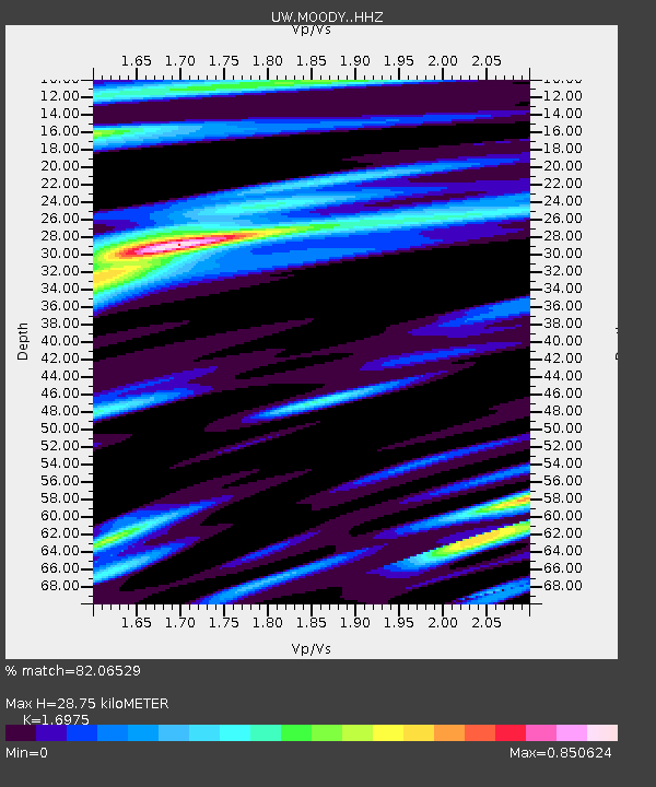
| Estimated Moho Depth: |
28.75 km |
| Estimated Crust Vp/Vs: |
1.70 |
| Assumed Crust Vp: |
6.134 km/s |
| Estimated Crust Vs: |
3.613 km/s |
| Estimated Crust Poisson's Ratio: |
0.23 |
|
| Radial Match: |
82.06529 % |
| Radial Bump: |
400 |
| Transverse Match: |
77.82112 % |
| Transverse Bump: |
400 |
| SOD ConfigId: |
28208852 |
| Insert Time: |
2022-07-24 22:52:11.314 +0000 |
| GWidth: |
2.5 |
| Max Bumps: |
400 |
| Tol: |
0.001 |
|

Signal To Noise
| Channel | StoN | STA | LTA |
| UW:MOODY: :HHZ:20220710T22:31:13.700Z | 6.9222465 | 7.2343107E-7 | 1.0450813E-7 |
| UW:MOODY: :HHN:20220710T22:31:13.700Z | 0.9174416 | 1.064642E-7 | 1.1604466E-7 |
| UW:MOODY: :HHE:20220710T22:31:13.700Z | 1.3946407 | 1.8341683E-7 | 1.3151548E-7 |
| Arrivals |
| Ps | 3.4 SECOND |
| PpPs | 12 SECOND |
| PsPs/PpSs | 16 SECOND |


