You are here: Home > Network List > XM99 - Rio Grande Seismic Transect Stations List
> Station NM25 NewMexico25 > Earthquake Result Viewer
NM25 NewMexico25 - Earthquake Result Viewer
| Earthquake location: |
Tonga Islands |
| Earthquake latitude/longitude: |
-15.4/-173.4 |
| Earthquake time(UTC): |
2000/11/09 (314) 05:45:54 GMT |
| Earthquake Depth: |
53 km |
| Earthquake Magnitude: |
5.6 MB, 5.9 MW, 5.7 MW |
| Earthquake Catalog/Contributor: |
WHDF/NEIC |
|
| Network: |
XM Rio Grande Seismic Transect |
| Station: |
NM25 NewMexico25 |
| Lat/Lon: |
34.17 N/106.26 W |
| Elevation: |
1933 m |
|
| Distance: |
80.6 deg |
| Az: |
50.755 deg |
| Baz: |
244.264 deg |
| Ray Param: |
0.048044685 |
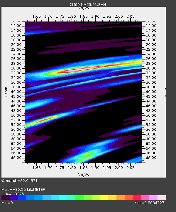
| Estimated Moho Depth: |
30.25 km |
| Estimated Crust Vp/Vs: |
1.84 |
| Assumed Crust Vp: |
6.502 km/s |
| Estimated Crust Vs: |
3.538 km/s |
| Estimated Crust Poisson's Ratio: |
0.29 |
|
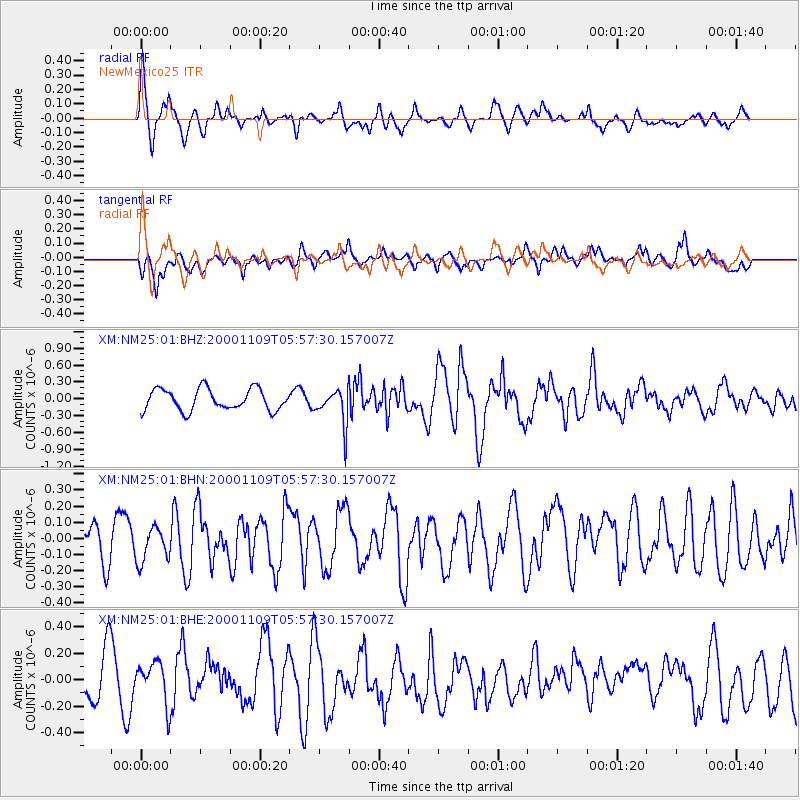
| Radial Match: |
82.04971 % |
| Radial Bump: |
400 |
| Transverse Match: |
64.37744 % |
| Transverse Bump: |
400 |
| SOD ConfigId: |
16820 |
| Insert Time: |
2010-02-26 17:33:10.735 +0000 |
| GWidth: |
2.5 |
| Max Bumps: |
400 |
| Tol: |
0.001 |
|
Signal To Noise
| Channel | StoN | STA | LTA |
| XM:NM25:01:BHN:20001109T05:57:30.157007Z | 0.81784356 | 1.073209E-7 | 1.3122424E-7 |
| XM:NM25:01:BHE:20001109T05:57:30.157007Z | 1.0668418 | 1.5674053E-7 | 1.4692013E-7 |
| XM:NM25:01:BHZ:20001109T05:57:30.157007Z | 1.6767217 | 3.170061E-7 | 1.8906304E-7 |
| Arrivals |
| Ps | 4.0 SECOND |
| PpPs | 13 SECOND |
| PsPs/PpSs | 17 SECOND |


