You are here: Home > Network List > NE - New England Seismic Network Stations List
> Station BCX Chestnut Hill, MA, USA > Earthquake Result Viewer
BCX Chestnut Hill, MA, USA - Earthquake Result Viewer
| Earthquake location: |
Panama-Colombia Border Region |
| Earthquake latitude/longitude: |
8.8/-77.3 |
| Earthquake time(UTC): |
2018/08/18 (230) 19:39:07 GMT |
| Earthquake Depth: |
10 km |
| Earthquake Magnitude: |
5.6 Mww |
| Earthquake Catalog/Contributor: |
NEIC PDE/us |
|
| Network: |
NE New England Seismic Network |
| Station: |
BCX Chestnut Hill, MA, USA |
| Lat/Lon: |
42.33 N/71.17 W |
| Elevation: |
60 m |
|
| Distance: |
33.8 deg |
| Az: |
8.173 deg |
| Baz: |
190.922 deg |
| Ray Param: |
0.078039184 |
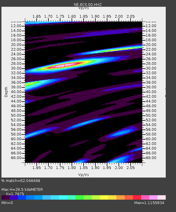
| Estimated Moho Depth: |
28.5 km |
| Estimated Crust Vp/Vs: |
1.77 |
| Assumed Crust Vp: |
6.419 km/s |
| Estimated Crust Vs: |
3.632 km/s |
| Estimated Crust Poisson's Ratio: |
0.26 |
|
| Radial Match: |
82.046486 % |
| Radial Bump: |
400 |
| Transverse Match: |
60.902637 % |
| Transverse Bump: |
400 |
| SOD ConfigId: |
2825771 |
| Insert Time: |
2018-09-02 01:48:45.111 +0000 |
| GWidth: |
2.5 |
| Max Bumps: |
400 |
| Tol: |
0.001 |
|

Signal To Noise
| Channel | StoN | STA | LTA |
| NE:BCX:00:HHZ:20180818T19:45:18.779009Z | 3.0437355 | 4.196647E-7 | 1.3787817E-7 |
| NE:BCX:00:HH1:20180818T19:45:18.779009Z | 3.7392342 | 2.9557066E-7 | 7.904577E-8 |
| NE:BCX:00:HH2:20180818T19:45:18.779009Z | 1.3375678 | 1.18456626E-7 | 8.8561215E-8 |
| Arrivals |
| Ps | 3.7 SECOND |
| PpPs | 11 SECOND |
| PsPs/PpSs | 15 SECOND |


