You are here: Home > Network List > AK - Alaska Regional Network Stations List
> Station N15K Kwethluk River, AK, USA > Earthquake Result Viewer
N15K Kwethluk River, AK, USA - Earthquake Result Viewer
| Earthquake location: |
Vanuatu Islands |
| Earthquake latitude/longitude: |
-18.1/169.0 |
| Earthquake time(UTC): |
2022/07/11 (192) 21:06:04 GMT |
| Earthquake Depth: |
10 km |
| Earthquake Magnitude: |
5.7 mww |
| Earthquake Catalog/Contributor: |
NEIC PDE/us |
|
| Network: |
AK Alaska Regional Network |
| Station: |
N15K Kwethluk River, AK, USA |
| Lat/Lon: |
60.17 N/160.09 W |
| Elevation: |
449 m |
|
| Distance: |
81.9 deg |
| Az: |
15.016 deg |
| Baz: |
209.526 deg |
| Ray Param: |
0.047236178 |
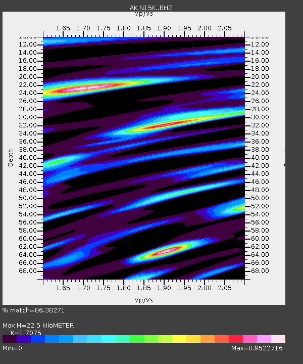
| Estimated Moho Depth: |
22.5 km |
| Estimated Crust Vp/Vs: |
1.71 |
| Assumed Crust Vp: |
6.182 km/s |
| Estimated Crust Vs: |
3.621 km/s |
| Estimated Crust Poisson's Ratio: |
0.24 |
|
| Radial Match: |
86.38271 % |
| Radial Bump: |
393 |
| Transverse Match: |
60.545975 % |
| Transverse Bump: |
400 |
| SOD ConfigId: |
28208852 |
| Insert Time: |
2022-07-25 21:10:54.837 +0000 |
| GWidth: |
2.5 |
| Max Bumps: |
400 |
| Tol: |
0.001 |
|

Signal To Noise
| Channel | StoN | STA | LTA |
| AK:N15K: :BHZ:20220711T21:17:52.859998Z | 2.3415458 | 1.9587408E-7 | 8.365161E-8 |
| AK:N15K: :BHN:20220711T21:17:52.859998Z | 1.8420638 | 1.3265911E-7 | 7.201657E-8 |
| AK:N15K: :BHE:20220711T21:17:52.859998Z | 0.8866061 | 8.939081E-8 | 1.0082359E-7 |
| Arrivals |
| Ps | 2.6 SECOND |
| PpPs | 9.6 SECOND |
| PsPs/PpSs | 12 SECOND |


