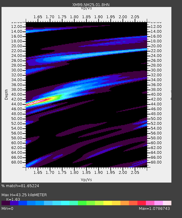
NM25 NewMexico25 - Earthquake Result Viewer

Earthquake location: Kodiak Island Region, Alaska
Earthquake latitude/longitude: 56.2/-153.5
Earthquake time(UTC): 2000/11/06 (311) 11:40:26 GMT
Earthquake Depth: 20 km
Earthquake Magnitude: 5.5 MB, 5.6 MS, 6.0 MW, 5.5 ML
Earthquake Catalog/Contributor: WHDF/NEIC
Network: XM Rio Grande Seismic Transect
Station: NM25 NewMexico25
Lat/Lon: 34.17 N/106.26 W
Elevation: 1933 m
Distance: 38.9 deg
Az: 104.215 deg
Baz: 319.138 deg
Ray Param: 0.07528751
Estimated Moho Depth: 43.25 km
Estimated Crust Vp/Vs: 1.63
Assumed Crust Vp: 6.502 km/s
Estimated Crust Vs: 3.989 km/s
Estimated Crust Poisson's Ratio: 0.20
Radial Match: 81.65224 %
Radial Bump: 400
Transverse Match: 63.94043 %
Transverse Bump: 400
SOD ConfigId: 16820
Insert Time: 2010-02-26 17:33:12.524 +0000
GWidth: 2.5
Max Bumps: 400
Tol: 0.001

Signal To Noise

ChannelStoNSTALTA
XM:NM25:01:BHN:20001106T11:47:20.005985Z2.19007873.1409323E-71.434164E-7
XM:NM25:01:BHE:20001106T11:47:20.005985Z2.57739522.8701444E-71.1135833E-7
XM:NM25:01:BHZ:20001106T11:47:20.005985Z4.5196323.315479E-77.3357285E-8
Arrivals
Ps4.5 SECOND
PpPs16 SECOND
PsPs/PpSs21 SECOND