You are here: Home > Network List > XM99 - Rio Grande Seismic Transect Stations List
> Station NM25 NewMexico25 > Earthquake Result Viewer
NM25 NewMexico25 - Earthquake Result Viewer
| Earthquake location: |
Tonga Islands |
| Earthquake latitude/longitude: |
-17.9/-175.3 |
| Earthquake time(UTC): |
2000/10/31 (305) 18:43:20 GMT |
| Earthquake Depth: |
33 km |
| Earthquake Magnitude: |
5.8 MB, 5.9 MS, 6.1 MW |
| Earthquake Catalog/Contributor: |
WHDF/NEIC |
|
| Network: |
XM Rio Grande Seismic Transect |
| Station: |
NM25 NewMexico25 |
| Lat/Lon: |
34.17 N/106.26 W |
| Elevation: |
1933 m |
|
| Distance: |
83.6 deg |
| Az: |
51.191 deg |
| Baz: |
243.513 deg |
| Ray Param: |
0.04604449 |
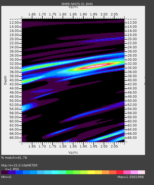
| Estimated Moho Depth: |
33.0 km |
| Estimated Crust Vp/Vs: |
1.96 |
| Assumed Crust Vp: |
6.502 km/s |
| Estimated Crust Vs: |
3.326 km/s |
| Estimated Crust Poisson's Ratio: |
0.32 |
|
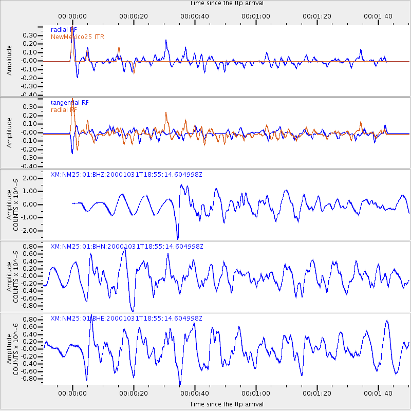
| Radial Match: |
81.76 % |
| Radial Bump: |
400 |
| Transverse Match: |
68.07316 % |
| Transverse Bump: |
400 |
| SOD ConfigId: |
16820 |
| Insert Time: |
2010-02-26 17:33:13.950 +0000 |
| GWidth: |
2.5 |
| Max Bumps: |
400 |
| Tol: |
0.001 |
|
Signal To Noise
| Channel | StoN | STA | LTA |
| XM:NM25:01:BHN:20001031T18:55:14.604998Z | 1.6551836 | 3.6533396E-7 | 2.207211E-7 |
| XM:NM25:01:BHE:20001031T18:55:14.604998Z | 1.436873 | 2.9944096E-7 | 2.0839767E-7 |
| XM:NM25:01:BHZ:20001031T18:55:14.604998Z | 2.2321415 | 9.638154E-7 | 4.3178954E-7 |
| Arrivals |
| Ps | 5.0 SECOND |
| PpPs | 15 SECOND |
| PsPs/PpSs | 20 SECOND |


