You are here: Home > Network List > TX - Texas Seismological Network Stations List
> Station PB19 West of Imperial > Earthquake Result Viewer
PB19 West of Imperial - Earthquake Result Viewer
| Earthquake location: |
Vanuatu Islands |
| Earthquake latitude/longitude: |
-18.1/169.0 |
| Earthquake time(UTC): |
2022/07/11 (192) 21:06:04 GMT |
| Earthquake Depth: |
10 km |
| Earthquake Magnitude: |
5.7 mww |
| Earthquake Catalog/Contributor: |
NEIC PDE/us |
|
| Network: |
TX Texas Seismological Network |
| Station: |
PB19 West of Imperial |
| Lat/Lon: |
31.30 N/103.10 W |
| Elevation: |
782 m |
|
| Distance: |
97.4 deg |
| Az: |
59.616 deg |
| Baz: |
253.411 deg |
| Ray Param: |
0.040215448 |
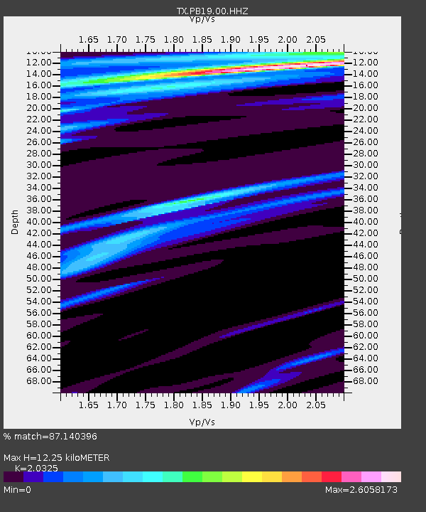
| Estimated Moho Depth: |
12.25 km |
| Estimated Crust Vp/Vs: |
2.03 |
| Assumed Crust Vp: |
6.121 km/s |
| Estimated Crust Vs: |
3.011 km/s |
| Estimated Crust Poisson's Ratio: |
0.34 |
|
| Radial Match: |
87.140396 % |
| Radial Bump: |
159 |
| Transverse Match: |
86.60791 % |
| Transverse Bump: |
216 |
| SOD ConfigId: |
28208852 |
| Insert Time: |
2022-07-25 21:26:11.855 +0000 |
| GWidth: |
2.5 |
| Max Bumps: |
400 |
| Tol: |
0.001 |
|

Signal To Noise
| Channel | StoN | STA | LTA |
| TX:PB19:00:HHZ:20220711T21:19:06.534986Z | 1.9711239 | 3.5767157E-6 | 1.8145564E-6 |
| TX:PB19:00:HHN:20220711T21:19:06.534986Z | 2.0563073 | 9.812193E-6 | 4.771754E-6 |
| TX:PB19:00:HHE:20220711T21:19:06.534986Z | 1.6533704 | 6.9910975E-6 | 4.228392E-6 |
| Arrivals |
| Ps | 2.1 SECOND |
| PpPs | 6.0 SECOND |
| PsPs/PpSs | 8.1 SECOND |


