You are here: Home > Network List > AV - Alaska Volcano Observatory Stations List
> Station MAPS Pakushin Southeast, Makushin Volcano, Alaska > Earthquake Result Viewer
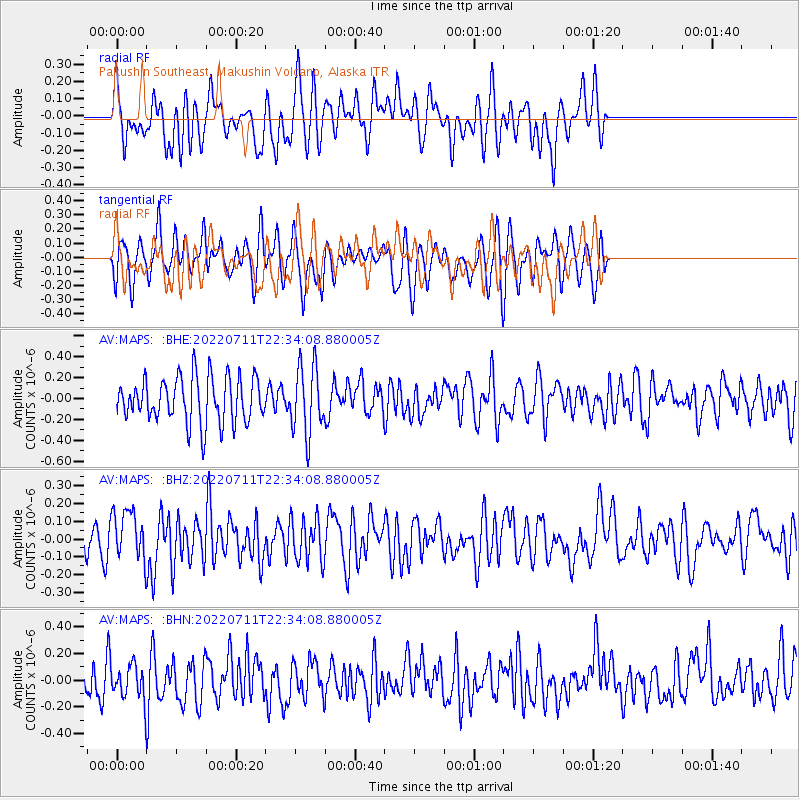
MAPS Pakushin Southeast, Makushin Volcano, Alaska - Earthquake Result Viewer
*The percent match for this event was below the threshold and hence no stack was calculated.
| Earthquake location: |
Samoa Islands Region |
| Earthquake latitude/longitude: |
-15.2/-172.6 |
| Earthquake time(UTC): |
2022/07/11 (192) 22:23:35 GMT |
| Earthquake Depth: |
10 km |
| Earthquake Magnitude: |
6.0 Mi |
| Earthquake Catalog/Contributor: |
NEIC PDE/pt |
|
| Network: |
AV Alaska Volcano Observatory |
| Station: |
MAPS Pakushin Southeast, Makushin Volcano, Alaska |
| Lat/Lon: |
53.81 N/166.94 W |
| Elevation: |
333 m |
|
| Distance: |
68.9 deg |
| Az: |
3.579 deg |
| Baz: |
185.831 deg |
| Ray Param: |
$rayparam |
*The percent match for this event was below the threshold and hence was not used in the summary stack. |
|
| Radial Match: |
54.923054 % |
| Radial Bump: |
400 |
| Transverse Match: |
47.931927 % |
| Transverse Bump: |
400 |
| SOD ConfigId: |
28208852 |
| Insert Time: |
2022-07-25 22:30:28.646 +0000 |
| GWidth: |
2.5 |
| Max Bumps: |
400 |
| Tol: |
0.001 |
|
Signal To Noise
| Channel | StoN | STA | LTA |
| AV:MAPS: :BHZ:20220711T22:34:08.880005Z | 2.2955797 | 1.3744724E-7 | 5.987474E-8 |
| AV:MAPS: :BHN:20220711T22:34:08.880005Z | 0.8887422 | 1.1774722E-7 | 1.3248749E-7 |
| AV:MAPS: :BHE:20220711T22:34:08.880005Z | 1.4940219 | 3.25227E-7 | 2.1768557E-7 |
| Arrivals |
| Ps | |
| PpPs | |
| PsPs/PpSs | |


