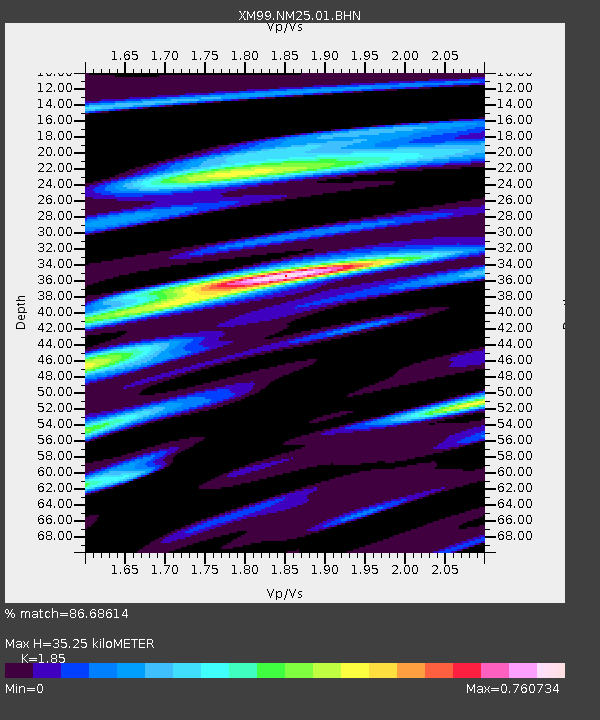
NM25 NewMexico25 - Earthquake Result Viewer

Earthquake location: Tonga Islands
Earthquake latitude/longitude: -20.8/-174.2
Earthquake time(UTC): 2000/01/02 (002) 15:16:32 GMT
Earthquake Depth: 33 km
Earthquake Magnitude: 5.5 MB, 5.8 MS, 5.8 MW, 5.8 MW
Earthquake Catalog/Contributor: WHDF/NEIC
Network: XM Rio Grande Seismic Transect
Station: NM25 NewMexico25
Lat/Lon: 34.17 N/106.26 W
Elevation: 1933 m
Distance: 84.6 deg
Az: 50.539 deg
Baz: 240.616 deg
Ray Param: 0.04531354
Estimated Moho Depth: 35.25 km
Estimated Crust Vp/Vs: 1.85
Assumed Crust Vp: 6.502 km/s
Estimated Crust Vs: 3.514 km/s
Estimated Crust Poisson's Ratio: 0.29
Radial Match: 86.68614 %
Radial Bump: 400
Transverse Match: 69.24513 %
Transverse Bump: 400
SOD ConfigId: 27569
Insert Time: 2010-02-26 17:33:24.390 +0000
GWidth: 2.5
Max Bumps: 400
Tol: 0.001

Signal To Noise

ChannelStoNSTALTA
XM:NM25:01:BHN:20000102T15:28:31.207002Z1.06850111.1968798E-71.1201483E-7
XM:NM25:01:BHE:20000102T15:28:31.207002Z0.75206337.6586986E-81.0183583E-7
XM:NM25:01:BHZ:20000102T15:28:31.207002Z1.3955891.617202E-71.1587953E-7
Arrivals
Ps4.7 SECOND
PpPs15 SECOND
PsPs/PpSs20 SECOND