You are here: Home > Network List > C8 - Canadian Seismic Research Network () Stations List
> Station GRNB Grenville Island, BC, CA > Earthquake Result Viewer
GRNB Grenville Island, BC, CA - Earthquake Result Viewer
| Earthquake location: |
Tonga Islands |
| Earthquake latitude/longitude: |
-15.2/-173.3 |
| Earthquake time(UTC): |
2022/07/11 (192) 22:23:36 GMT |
| Earthquake Depth: |
10 km |
| Earthquake Magnitude: |
5.6 Mww |
| Earthquake Catalog/Contributor: |
NEIC PDE/us |
|
| Network: |
C8 Canadian Seismic Research Network () |
| Station: |
GRNB Grenville Island, BC, CA |
| Lat/Lon: |
53.85 N/129.96 W |
| Elevation: |
461 m |
|
| Distance: |
78.1 deg |
| Az: |
24.572 deg |
| Baz: |
222.663 deg |
| Ray Param: |
0.049896065 |
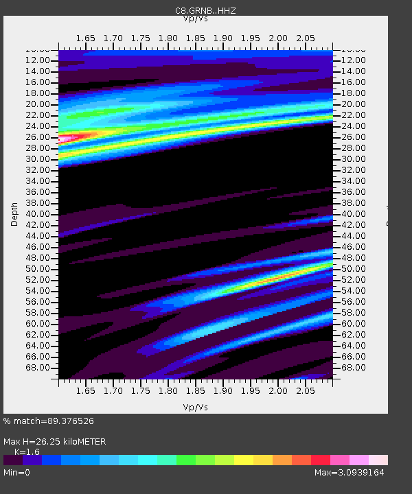
| Estimated Moho Depth: |
26.25 km |
| Estimated Crust Vp/Vs: |
1.60 |
| Assumed Crust Vp: |
6.545 km/s |
| Estimated Crust Vs: |
4.091 km/s |
| Estimated Crust Poisson's Ratio: |
0.18 |
|
| Radial Match: |
89.376526 % |
| Radial Bump: |
235 |
| Transverse Match: |
88.29331 % |
| Transverse Bump: |
371 |
| SOD ConfigId: |
28208852 |
| Insert Time: |
2022-07-25 23:00:04.012 +0000 |
| GWidth: |
2.5 |
| Max Bumps: |
400 |
| Tol: |
0.001 |
|
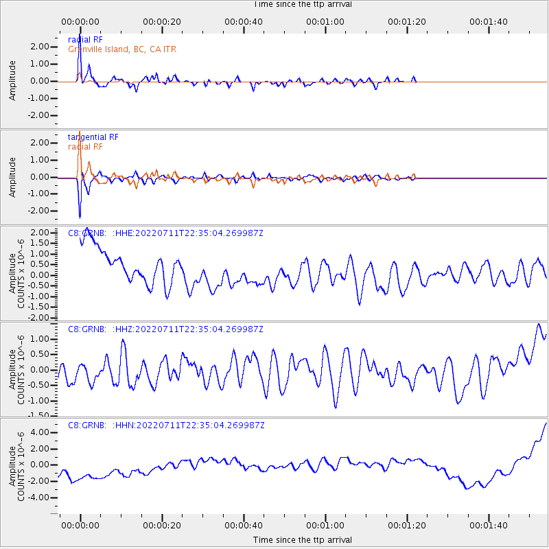
Signal To Noise
| Channel | StoN | STA | LTA |
| C8:GRNB: :HHZ:20220711T22:35:04.269987Z | 0.95948964 | 8.2120147E-7 | 8.5587317E-7 |
| C8:GRNB: :HHN:20220711T22:35:04.269987Z | 1.1380391 | 4.519851E-6 | 3.9716133E-6 |
| C8:GRNB: :HHE:20220711T22:35:04.269987Z | 1.201425 | 9.586047E-7 | 7.978898E-7 |
| Arrivals |
| Ps | 2.5 SECOND |
| PpPs | 10 SECOND |
| PsPs/PpSs | 13 SECOND |


