You are here: Home > Network List > XM99 - Rio Grande Seismic Transect Stations List
> Station NM25 NewMexico25 > Earthquake Result Viewer
NM25 NewMexico25 - Earthquake Result Viewer
| Earthquake location: |
Fiji Islands Region |
| Earthquake latitude/longitude: |
-18.1/-176.9 |
| Earthquake time(UTC): |
2001/04/28 (118) 04:49:53 GMT |
| Earthquake Depth: |
352 km |
| Earthquake Magnitude: |
6.2 MB, 6.8 MW, 6.8 MW |
| Earthquake Catalog/Contributor: |
WHDF/NEIC |
|
| Network: |
XM Rio Grande Seismic Transect |
| Station: |
NM25 NewMexico25 |
| Lat/Lon: |
34.17 N/106.26 W |
| Elevation: |
1933 m |
|
| Distance: |
84.9 deg |
| Az: |
51.771 deg |
| Baz: |
244.327 deg |
| Ray Param: |
0.04423383 |
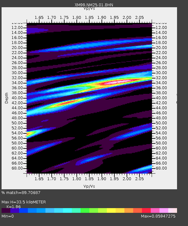
| Estimated Moho Depth: |
33.5 km |
| Estimated Crust Vp/Vs: |
1.96 |
| Assumed Crust Vp: |
6.502 km/s |
| Estimated Crust Vs: |
3.317 km/s |
| Estimated Crust Poisson's Ratio: |
0.32 |
|
| Radial Match: |
89.70687 % |
| Radial Bump: |
314 |
| Transverse Match: |
65.68883 % |
| Transverse Bump: |
400 |
| SOD ConfigId: |
4714 |
| Insert Time: |
2010-02-26 17:33:28.207 +0000 |
| GWidth: |
2.5 |
| Max Bumps: |
400 |
| Tol: |
0.001 |
|
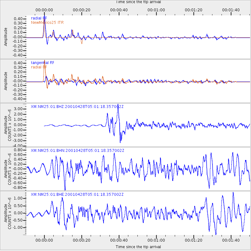
Signal To Noise
| Channel | StoN | STA | LTA |
| XM:NM25:01:BHN:20010428T05:01:18.357002Z | 3.011662 | 2.056742E-7 | 6.8292586E-8 |
| XM:NM25:01:BHE:20010428T05:01:18.357002Z | 3.3956811 | 3.698229E-7 | 1.08909795E-7 |
| XM:NM25:01:BHZ:20010428T05:01:18.357002Z | 6.98564 | 7.195924E-7 | 1.0301023E-7 |
| Arrivals |
| Ps | 5.1 SECOND |
| PpPs | 15 SECOND |
| PsPs/PpSs | 20 SECOND |


