You are here: Home > Network List > XM99 - Rio Grande Seismic Transect Stations List
> Station NM25 NewMexico25 > Earthquake Result Viewer
NM25 NewMexico25 - Earthquake Result Viewer
| Earthquake location: |
Kodiak Island Region, Alaska |
| Earthquake latitude/longitude: |
57.4/-154.5 |
| Earthquake time(UTC): |
1999/12/06 (340) 23:12:33 GMT |
| Earthquake Depth: |
66 km |
| Earthquake Magnitude: |
6.8 MB, 7.0 MW, 7.0 ML |
| Earthquake Catalog/Contributor: |
WHDF/NEIC |
|
| Network: |
XM Rio Grande Seismic Transect |
| Station: |
NM25 NewMexico25 |
| Lat/Lon: |
34.17 N/106.26 W |
| Elevation: |
1933 m |
|
| Distance: |
39.7 deg |
| Az: |
104.677 deg |
| Baz: |
320.85 deg |
| Ray Param: |
0.0746081 |
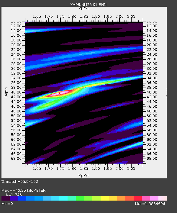
| Estimated Moho Depth: |
40.25 km |
| Estimated Crust Vp/Vs: |
1.75 |
| Assumed Crust Vp: |
6.502 km/s |
| Estimated Crust Vs: |
3.726 km/s |
| Estimated Crust Poisson's Ratio: |
0.26 |
|
| Radial Match: |
95.94102 % |
| Radial Bump: |
342 |
| Transverse Match: |
87.75866 % |
| Transverse Bump: |
400 |
| SOD ConfigId: |
27569 |
| Insert Time: |
2010-02-26 17:33:29.613 +0000 |
| GWidth: |
2.5 |
| Max Bumps: |
400 |
| Tol: |
0.001 |
|
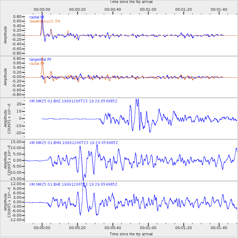
Signal To Noise
| Channel | StoN | STA | LTA |
| XM:NM25:01:BHN:19991206T23:19:29.654985Z | 6.547787 | 1.3041996E-6 | 1.9918174E-7 |
| XM:NM25:01:BHE:19991206T23:19:29.654985Z | 7.231922 | 1.0718917E-6 | 1.482167E-7 |
| XM:NM25:01:BHZ:19991206T23:19:29.654985Z | 11.953372 | 2.814711E-6 | 2.3547423E-7 |
| Arrivals |
| Ps | 5.0 SECOND |
| PpPs | 16 SECOND |
| PsPs/PpSs | 21 SECOND |


