You are here: Home > Network List > US - United States National Seismic Network Stations List
> Station AMTX Amarillo, Texas, USA > Earthquake Result Viewer
AMTX Amarillo, Texas, USA - Earthquake Result Viewer
| Earthquake location: |
Tonga Islands |
| Earthquake latitude/longitude: |
-15.2/-173.3 |
| Earthquake time(UTC): |
2022/07/11 (192) 22:23:36 GMT |
| Earthquake Depth: |
10 km |
| Earthquake Magnitude: |
5.6 Mww |
| Earthquake Catalog/Contributor: |
NEIC PDE/us |
|
| Network: |
US United States National Seismic Network |
| Station: |
AMTX Amarillo, Texas, USA |
| Lat/Lon: |
34.53 N/101.41 W |
| Elevation: |
1010 m |
|
| Distance: |
84.2 deg |
| Az: |
52.077 deg |
| Baz: |
247.313 deg |
| Ray Param: |
0.045640867 |
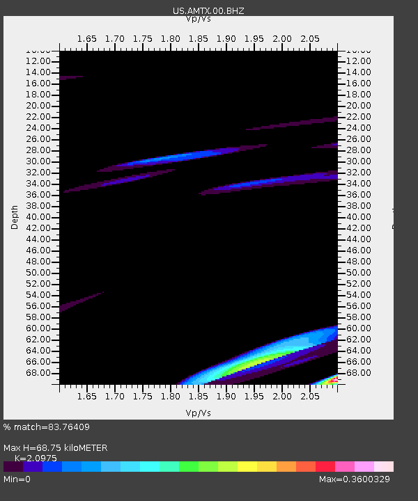
| Estimated Moho Depth: |
68.75 km |
| Estimated Crust Vp/Vs: |
2.10 |
| Assumed Crust Vp: |
6.426 km/s |
| Estimated Crust Vs: |
3.064 km/s |
| Estimated Crust Poisson's Ratio: |
0.35 |
|
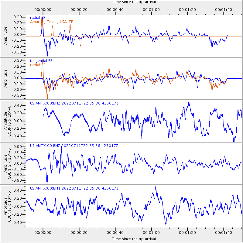
| Radial Match: |
83.76409 % |
| Radial Bump: |
400 |
| Transverse Match: |
74.98593 % |
| Transverse Bump: |
362 |
| SOD ConfigId: |
28208852 |
| Insert Time: |
2022-07-25 23:16:40.013 +0000 |
| GWidth: |
2.5 |
| Max Bumps: |
400 |
| Tol: |
0.001 |
|
Signal To Noise
| Channel | StoN | STA | LTA |
| US:AMTX:00:BHZ:20220711T22:35:36.425017Z | 2.0814164 | 4.5877795E-7 | 2.2041621E-7 |
| US:AMTX:00:BH1:20220711T22:35:36.425017Z | 1.2297169 | 1.3353342E-7 | 1.0858874E-7 |
| US:AMTX:00:BH2:20220711T22:35:36.425017Z | 0.94944566 | 1.8111238E-7 | 1.9075593E-7 |
| Arrivals |
| Ps | 12 SECOND |
| PpPs | 32 SECOND |
| PsPs/PpSs | 44 SECOND |


