You are here: Home > Network List > UW - Pacific Northwest Regional Seismic Network Stations List
> Station UMAT Pilot Rock, OR, USA > Earthquake Result Viewer
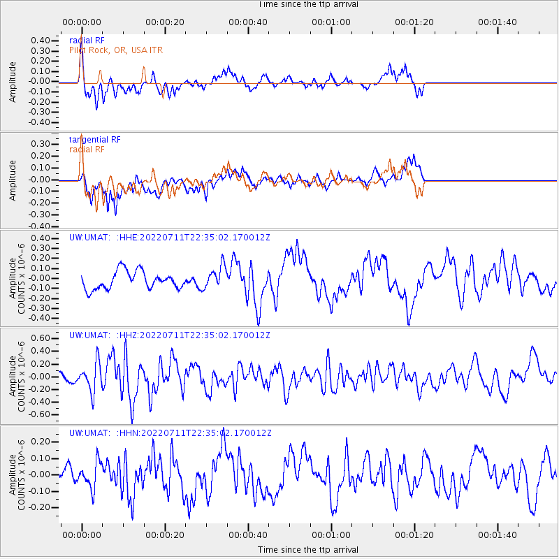
UMAT Pilot Rock, OR, USA - Earthquake Result Viewer
*The percent match for this event was below the threshold and hence no stack was calculated.
| Earthquake location: |
Tonga Islands |
| Earthquake latitude/longitude: |
-15.2/-173.3 |
| Earthquake time(UTC): |
2022/07/11 (192) 22:23:36 GMT |
| Earthquake Depth: |
10 km |
| Earthquake Magnitude: |
5.6 Mww |
| Earthquake Catalog/Contributor: |
NEIC PDE/us |
|
| Network: |
UW Pacific Northwest Regional Seismic Network |
| Station: |
UMAT Pilot Rock, OR, USA |
| Lat/Lon: |
45.29 N/118.96 W |
| Elevation: |
1318 m |
|
| Distance: |
77.7 deg |
| Az: |
35.958 deg |
| Baz: |
233.441 deg |
| Ray Param: |
$rayparam |
*The percent match for this event was below the threshold and hence was not used in the summary stack. |
|
| Radial Match: |
79.33741 % |
| Radial Bump: |
400 |
| Transverse Match: |
75.409515 % |
| Transverse Bump: |
400 |
| SOD ConfigId: |
28208852 |
| Insert Time: |
2022-07-25 23:18:39.199 +0000 |
| GWidth: |
2.5 |
| Max Bumps: |
400 |
| Tol: |
0.001 |
|
Signal To Noise
| Channel | StoN | STA | LTA |
| UW:UMAT: :HHZ:20220711T22:35:02.170012Z | 2.5825853 | 2.3494253E-7 | 9.097184E-8 |
| UW:UMAT: :HHN:20220711T22:35:02.170012Z | 1.2138546 | 8.1511615E-8 | 6.7151056E-8 |
| UW:UMAT: :HHE:20220711T22:35:02.170012Z | 1.3074485 | 1.1511424E-7 | 8.804495E-8 |
| Arrivals |
| Ps | |
| PpPs | |
| PsPs/PpSs | |


