NM25 NewMexico25 - Earthquake Result Viewer
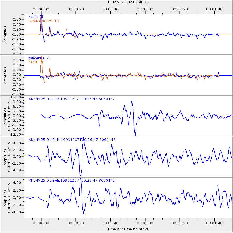
Earthquake location: Kodiak Island Region, Alaska
Earthquake latitude/longitude: 57.4/-154.5
Earthquake time(UTC): 1999/12/07 (341) 00:19:49 GMT
Earthquake Depth: 41 km
Earthquake Magnitude: 6.5 MB, 6.1 MS, 6.4 MW, 6.3 ML
Earthquake Catalog/Contributor: WHDF/NEIC
Network: XM Rio Grande Seismic Transect
Station: NM25 NewMexico25
Lat/Lon: 34.17 N/106.26 W
Elevation: 1933 m
Distance: 39.7 deg
Az: 104.593 deg
Baz: 320.767 deg
Ray Param: 0.074714795
Estimated Moho Depth: 40.75 km
Estimated Crust Vp/Vs: 1.75
Assumed Crust Vp: 6.502 km/s
Estimated Crust Vs: 3.715 km/s
Estimated Crust Poisson's Ratio: 0.26
Radial Match: 86.93638 %
Radial Bump: 306
Transverse Match: 62.81251 %
Transverse Bump: 400
SOD ConfigId: 27569
Insert Time: 2010-02-26 17:33:31.068 +0000
GWidth: 2.5
Max Bumps: 400
Tol: 0.001

Signal To Noise

ChannelStoNSTALTA
XM:NM25:01:BHN:19991207T00:26:47.806014Z2.36912921.3121704E-65.538619E-7
XM:NM25:01:BHE:19991207T00:26:47.806014Z2.8728129.71301E-73.3810116E-7
XM:NM25:01:BHZ:19991207T00:26:47.806014Z2.63598542.1692717E-68.229453E-7
Arrivals
Ps5.1 SECOND
PpPs16 SECOND
PsPs/PpSs21 SECOND