You are here: Home > Network List > AK - Alaska Regional Network Stations List
> Station L14K Kuka Creek, AK, USA > Earthquake Result Viewer
L14K Kuka Creek, AK, USA - Earthquake Result Viewer
| Earthquake location: |
Samoa Islands Region |
| Earthquake latitude/longitude: |
-15.3/-172.9 |
| Earthquake time(UTC): |
2022/07/12 (193) 00:35:05 GMT |
| Earthquake Depth: |
10 km |
| Earthquake Magnitude: |
5.5 mb |
| Earthquake Catalog/Contributor: |
NEIC PDE/us |
|
| Network: |
AK Alaska Regional Network |
| Station: |
L14K Kuka Creek, AK, USA |
| Lat/Lon: |
61.34 N/162.68 W |
| Elevation: |
41 m |
|
| Distance: |
76.8 deg |
| Az: |
5.064 deg |
| Baz: |
190.179 deg |
| Ray Param: |
0.050772037 |
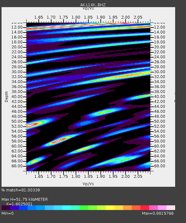
| Estimated Moho Depth: |
51.75 km |
| Estimated Crust Vp/Vs: |
1.60 |
| Assumed Crust Vp: |
6.1 km/s |
| Estimated Crust Vs: |
3.807 km/s |
| Estimated Crust Poisson's Ratio: |
0.18 |
|
| Radial Match: |
81.00339 % |
| Radial Bump: |
400 |
| Transverse Match: |
69.85652 % |
| Transverse Bump: |
400 |
| SOD ConfigId: |
28208852 |
| Insert Time: |
2022-07-26 00:39:24.426 +0000 |
| GWidth: |
2.5 |
| Max Bumps: |
400 |
| Tol: |
0.001 |
|

Signal To Noise
| Channel | StoN | STA | LTA |
| AK:L14K: :BHZ:20220712T00:46:25.740024Z | 5.4399176 | 4.2463844E-7 | 7.805972E-8 |
| AK:L14K: :BHN:20220712T00:46:25.740024Z | 1.7967558 | 1.916717E-7 | 1.06676545E-7 |
| AK:L14K: :BHE:20220712T00:46:25.740024Z | 0.95596325 | 8.954688E-8 | 9.367189E-8 |
| Arrivals |
| Ps | 5.3 SECOND |
| PpPs | 21 SECOND |
| PsPs/PpSs | 27 SECOND |


