You are here: Home > Network List > UU - University of Utah Regional Network Stations List
> Station HMU Henry Mountain, UT, USA > Earthquake Result Viewer
HMU Henry Mountain, UT, USA - Earthquake Result Viewer
| Earthquake location: |
Fiji Islands Region |
| Earthquake latitude/longitude: |
-18.1/-178.1 |
| Earthquake time(UTC): |
2018/08/19 (231) 00:30:41 GMT |
| Earthquake Depth: |
580 km |
| Earthquake Magnitude: |
5.6 mb |
| Earthquake Catalog/Contributor: |
NEIC PDE/us |
|
| Network: |
UU University of Utah Regional Network |
| Station: |
HMU Henry Mountain, UT, USA |
| Lat/Lon: |
37.94 N/110.74 W |
| Elevation: |
2430 m |
|
| Distance: |
84.3 deg |
| Az: |
47.193 deg |
| Baz: |
241.956 deg |
| Ray Param: |
0.043910168 |
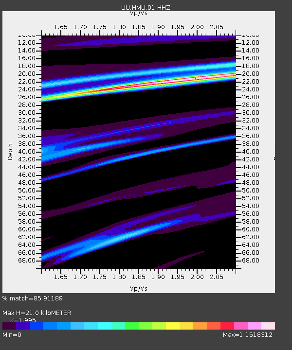
| Estimated Moho Depth: |
21.0 km |
| Estimated Crust Vp/Vs: |
2.00 |
| Assumed Crust Vp: |
6.247 km/s |
| Estimated Crust Vs: |
3.131 km/s |
| Estimated Crust Poisson's Ratio: |
0.33 |
|
| Radial Match: |
85.91189 % |
| Radial Bump: |
400 |
| Transverse Match: |
55.24575 % |
| Transverse Bump: |
400 |
| SOD ConfigId: |
2825771 |
| Insert Time: |
2018-09-02 02:00:27.537 +0000 |
| GWidth: |
2.5 |
| Max Bumps: |
400 |
| Tol: |
0.001 |
|

Signal To Noise
| Channel | StoN | STA | LTA |
| UU:HMU:01:HHZ:20180819T00:41:41.967974Z | 3.3972857 | 2.7946107E-6 | 8.2260107E-7 |
| UU:HMU:01:HHN:20180819T00:41:41.967974Z | 2.2214174 | 1.6048176E-6 | 7.2242955E-7 |
| UU:HMU:01:HHE:20180819T00:41:41.967974Z | 4.6969514 | 2.8010356E-6 | 5.963518E-7 |
| Arrivals |
| Ps | 3.4 SECOND |
| PpPs | 9.9 SECOND |
| PsPs/PpSs | 13 SECOND |


