You are here: Home > Network List > CC - Cascade Chain Volcano Monitoring Stations List
> Station KAUT Kautz Creek Helibase > Earthquake Result Viewer
KAUT Kautz Creek Helibase - Earthquake Result Viewer
| Earthquake location: |
Samoa Islands Region |
| Earthquake latitude/longitude: |
-15.3/-172.9 |
| Earthquake time(UTC): |
2022/07/12 (193) 00:35:05 GMT |
| Earthquake Depth: |
10 km |
| Earthquake Magnitude: |
5.5 mb |
| Earthquake Catalog/Contributor: |
NEIC PDE/us |
|
| Network: |
CC Cascade Chain Volcano Monitoring |
| Station: |
KAUT Kautz Creek Helibase |
| Lat/Lon: |
46.73 N/121.86 W |
| Elevation: |
689 m |
|
| Distance: |
76.9 deg |
| Az: |
33.343 deg |
| Baz: |
230.467 deg |
| Ray Param: |
0.050708752 |
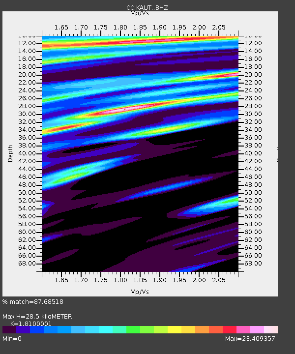
| Estimated Moho Depth: |
28.5 km |
| Estimated Crust Vp/Vs: |
1.81 |
| Assumed Crust Vp: |
6.597 km/s |
| Estimated Crust Vs: |
3.645 km/s |
| Estimated Crust Poisson's Ratio: |
0.28 |
|
| Radial Match: |
87.68518 % |
| Radial Bump: |
363 |
| Transverse Match: |
83.93251 % |
| Transverse Bump: |
342 |
| SOD ConfigId: |
28208852 |
| Insert Time: |
2022-07-26 00:45:52.312 +0000 |
| GWidth: |
2.5 |
| Max Bumps: |
400 |
| Tol: |
0.001 |
|

Signal To Noise
| Channel | StoN | STA | LTA |
| CC:KAUT: :BHZ:20220712T00:46:26.259982Z | 0.5401765 | 2.2399227E-7 | 4.1466498E-7 |
| CC:KAUT: :BHN:20220712T00:46:26.259982Z | 0.85769933 | 1.9871726E-5 | 2.3168639E-5 |
| CC:KAUT: :BHE:20220712T00:46:26.259982Z | 1.2776034 | 5.8055307E-6 | 4.5440793E-6 |
| Arrivals |
| Ps | 3.6 SECOND |
| PpPs | 12 SECOND |
| PsPs/PpSs | 15 SECOND |


