You are here: Home > Network List > TW - Broadband Array in Taiwan for Seismology Stations List
> Station YHNB YE-HENG, Taoyuan > Earthquake Result Viewer
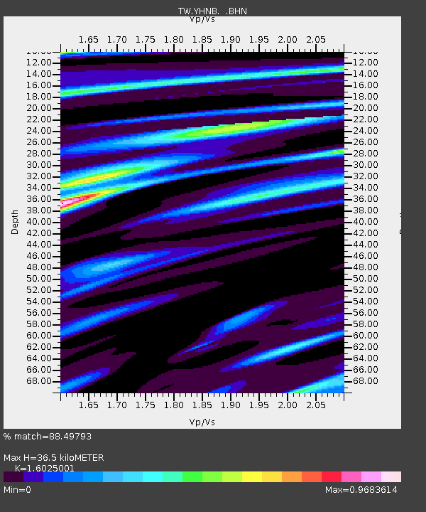
YHNB YE-HENG, Taoyuan - Earthquake Result Viewer
| Earthquake location: |
Java, Indonesia |
| Earthquake latitude/longitude: |
-7.8/107.3 |
| Earthquake time(UTC): |
2009/09/02 (245) 07:55:01 GMT |
| Earthquake Depth: |
46 km |
| Earthquake Magnitude: |
6.8 MB, 7.0 MS, 7.0 MW, 7.0 MW |
| Earthquake Catalog/Contributor: |
WHDF/NEIC |
|
| Network: |
TW Broadband Array in Taiwan for Seismology |
| Station: |
YHNB YE-HENG, Taoyuan |
| Lat/Lon: |
24.67 N/121.37 E |
| Elevation: |
775 m |
|
| Distance: |
35.1 deg |
| Az: |
22.662 deg |
| Baz: |
204.813 deg |
| Ray Param: |
0.07731735 |
| Estimated Moho Depth: |
36.5 km |
| Estimated Crust Vp/Vs: |
1.60 |
| Assumed Crust Vp: |
6.289 km/s |
| Estimated Crust Vs: |
3.924 km/s |
| Estimated Crust Poisson's Ratio: |
0.18 |
|
| Radial Match: |
88.49793 % |
| Radial Bump: |
338 |
| Transverse Match: |
67.35053 % |
| Transverse Bump: |
400 |
| SOD ConfigId: |
2622 |
| Insert Time: |
2010-03-09 22:15:59.760 +0000 |
| GWidth: |
2.5 |
| Max Bumps: |
400 |
| Tol: |
0.001 |
|

Signal To Noise
| Channel | StoN | STA | LTA |
| TW:YHNB: :BHN:20090902T08:01:19.220013Z | 48.405426 | 1.8247536E-5 | 3.7697293E-7 |
| TW:YHNB: :BHE:20090902T08:01:19.220013Z | 25.91061 | 8.132597E-6 | 3.138713E-7 |
| TW:YHNB: :BHZ:20090902T08:01:19.220013Z | 15.863183 | 4.2729325E-6 | 2.693616E-7 |
| Arrivals |
| Ps | 3.8 SECOND |
| PpPs | 14 SECOND |
| PsPs/PpSs | 18 SECOND |


