You are here: Home > Network List > O2 - Oklahoma Consolidated Temporary Seismic Networks Stations List
> Station CVNG Covington, Oklahoma, USA > Earthquake Result Viewer
CVNG Covington, Oklahoma, USA - Earthquake Result Viewer
| Earthquake location: |
Samoa Islands Region |
| Earthquake latitude/longitude: |
-15.3/-172.9 |
| Earthquake time(UTC): |
2022/07/12 (193) 00:35:05 GMT |
| Earthquake Depth: |
10 km |
| Earthquake Magnitude: |
5.5 mb |
| Earthquake Catalog/Contributor: |
NEIC PDE/us |
|
| Network: |
O2 Oklahoma Consolidated Temporary Seismic Networks |
| Station: |
CVNG Covington, Oklahoma, USA |
| Lat/Lon: |
36.32 N/97.43 W |
| Elevation: |
358 m |
|
| Distance: |
87.7 deg |
| Az: |
51.5 deg |
| Baz: |
249.278 deg |
| Ray Param: |
0.043164358 |
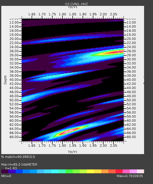
| Estimated Moho Depth: |
65.0 km |
| Estimated Crust Vp/Vs: |
1.83 |
| Assumed Crust Vp: |
6.483 km/s |
| Estimated Crust Vs: |
3.542 km/s |
| Estimated Crust Poisson's Ratio: |
0.29 |
|
| Radial Match: |
90.899315 % |
| Radial Bump: |
367 |
| Transverse Match: |
92.15648 % |
| Transverse Bump: |
286 |
| SOD ConfigId: |
28208852 |
| Insert Time: |
2022-07-26 00:54:09.044 +0000 |
| GWidth: |
2.5 |
| Max Bumps: |
400 |
| Tol: |
0.001 |
|

Signal To Noise
| Channel | StoN | STA | LTA |
| O2:CVNG: :HHZ:20220712T00:47:22.509982Z | 0.90387625 | 5.068582E-7 | 5.607606E-7 |
| O2:CVNG: :HHN:20220712T00:47:22.509982Z | 1.0374414 | 4.3954716E-7 | 4.2368384E-7 |
| O2:CVNG: :HHE:20220712T00:47:22.509982Z | 0.6779015 | 1.9648238E-7 | 2.8983914E-7 |
| Arrivals |
| Ps | 8.5 SECOND |
| PpPs | 28 SECOND |
| PsPs/PpSs | 36 SECOND |


