You are here: Home > Network List > TW - Broadband Array in Taiwan for Seismology Stations List
> Station YHNB YE-HENG, Taoyuan > Earthquake Result Viewer
YHNB YE-HENG, Taoyuan - Earthquake Result Viewer
| Earthquake location: |
South Of Java, Indonesia |
| Earthquake latitude/longitude: |
-9.4/108.3 |
| Earthquake time(UTC): |
2006/07/17 (198) 15:45:59 GMT |
| Earthquake Depth: |
21 km |
| Earthquake Magnitude: |
5.9 MB, 5.9 MS, 6.1 MW, 6.1 MW |
| Earthquake Catalog/Contributor: |
WHDF/NEIC |
|
| Network: |
TW Broadband Array in Taiwan for Seismology |
| Station: |
YHNB YE-HENG, Taoyuan |
| Lat/Lon: |
24.67 N/121.37 E |
| Elevation: |
775 m |
|
| Distance: |
36.2 deg |
| Az: |
20.365 deg |
| Baz: |
202.174 deg |
| Ray Param: |
0.07678403 |
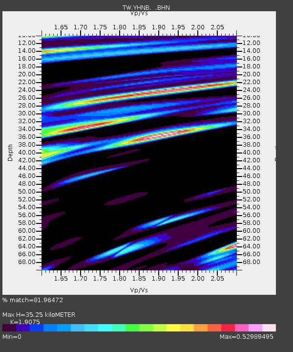
| Estimated Moho Depth: |
35.25 km |
| Estimated Crust Vp/Vs: |
1.91 |
| Assumed Crust Vp: |
6.289 km/s |
| Estimated Crust Vs: |
3.297 km/s |
| Estimated Crust Poisson's Ratio: |
0.31 |
|
| Radial Match: |
81.96472 % |
| Radial Bump: |
400 |
| Transverse Match: |
73.670715 % |
| Transverse Bump: |
400 |
| SOD ConfigId: |
5423 |
| Insert Time: |
2010-03-09 22:16:15.044 +0000 |
| GWidth: |
2.5 |
| Max Bumps: |
400 |
| Tol: |
0.001 |
|

Signal To Noise
| Channel | StoN | STA | LTA |
| TW:YHNB: :BHN:20060717T15:52:30.270012Z | 3.517123 | 1.0831263E-6 | 3.0795803E-7 |
| TW:YHNB: :BHE:20060717T15:52:30.270012Z | 2.954314 | 8.738055E-7 | 2.9577274E-7 |
| TW:YHNB: :BHZ:20060717T15:52:30.270012Z | 9.652842 | 2.796612E-6 | 2.8971905E-7 |
| Arrivals |
| Ps | 5.4 SECOND |
| PpPs | 15 SECOND |
| PsPs/PpSs | 21 SECOND |


