You are here: Home > Network List > US - United States National Seismic Network Stations List
> Station AMTX Amarillo, Texas, USA > Earthquake Result Viewer
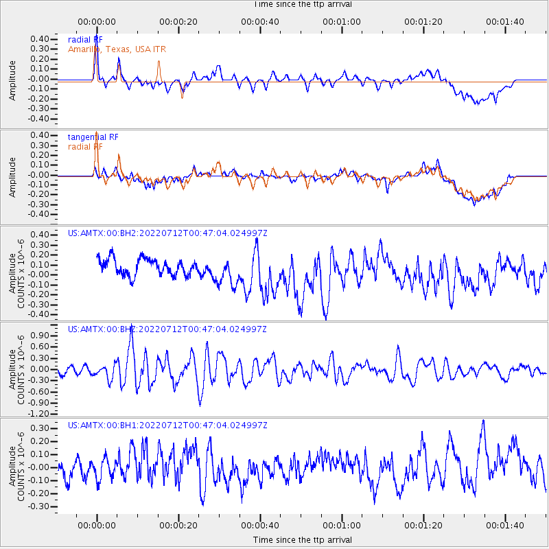
AMTX Amarillo, Texas, USA - Earthquake Result Viewer
*The percent match for this event was below the threshold and hence no stack was calculated.
| Earthquake location: |
Samoa Islands Region |
| Earthquake latitude/longitude: |
-15.3/-172.9 |
| Earthquake time(UTC): |
2022/07/12 (193) 00:35:05 GMT |
| Earthquake Depth: |
10 km |
| Earthquake Magnitude: |
5.5 mb |
| Earthquake Catalog/Contributor: |
NEIC PDE/us |
|
| Network: |
US United States National Seismic Network |
| Station: |
AMTX Amarillo, Texas, USA |
| Lat/Lon: |
34.53 N/101.41 W |
| Elevation: |
1010 m |
|
| Distance: |
84.0 deg |
| Az: |
51.949 deg |
| Baz: |
247.017 deg |
| Ray Param: |
$rayparam |
*The percent match for this event was below the threshold and hence was not used in the summary stack. |
|
| Radial Match: |
59.638054 % |
| Radial Bump: |
400 |
| Transverse Match: |
38.41682 % |
| Transverse Bump: |
400 |
| SOD ConfigId: |
28208852 |
| Insert Time: |
2022-07-26 01:02:09.005 +0000 |
| GWidth: |
2.5 |
| Max Bumps: |
400 |
| Tol: |
0.001 |
|
Signal To Noise
| Channel | StoN | STA | LTA |
| US:AMTX:00:BHZ:20220712T00:47:04.024997Z | 2.5151618 | 1.8869324E-7 | 7.502231E-8 |
| US:AMTX:00:BH1:20220712T00:47:04.024997Z | 1.2706131 | 8.581574E-8 | 6.753884E-8 |
| US:AMTX:00:BH2:20220712T00:47:04.024997Z | 1.8159918 | 1.459289E-7 | 8.035768E-8 |
| Arrivals |
| Ps | |
| PpPs | |
| PsPs/PpSs | |


