You are here: Home > Network List > TW - Broadband Array in Taiwan for Seismology Stations List
> Station YHNB YE-HENG, Taoyuan > Earthquake Result Viewer
YHNB YE-HENG, Taoyuan - Earthquake Result Viewer
| Earthquake location: |
East Of Kuril Islands |
| Earthquake latitude/longitude: |
48.8/156.3 |
| Earthquake time(UTC): |
2004/12/18 (353) 06:46:19 GMT |
| Earthquake Depth: |
11 km |
| Earthquake Magnitude: |
5.5 MB, 6.1 MS, 6.2 MW, 6.1 MW |
| Earthquake Catalog/Contributor: |
WHDF/NEIC |
|
| Network: |
TW Broadband Array in Taiwan for Seismology |
| Station: |
YHNB YE-HENG, Taoyuan |
| Lat/Lon: |
24.67 N/121.37 E |
| Elevation: |
775 m |
|
| Distance: |
36.5 deg |
| Az: |
241.266 deg |
| Baz: |
39.553 deg |
| Ray Param: |
0.076671064 |
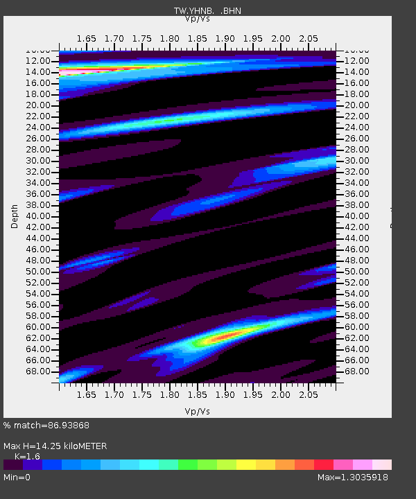
| Estimated Moho Depth: |
14.25 km |
| Estimated Crust Vp/Vs: |
1.60 |
| Assumed Crust Vp: |
6.289 km/s |
| Estimated Crust Vs: |
3.93 km/s |
| Estimated Crust Poisson's Ratio: |
0.18 |
|
| Radial Match: |
86.93868 % |
| Radial Bump: |
400 |
| Transverse Match: |
57.61275 % |
| Transverse Bump: |
400 |
| SOD ConfigId: |
2459 |
| Insert Time: |
2010-03-09 22:16:36.831 +0000 |
| GWidth: |
2.5 |
| Max Bumps: |
400 |
| Tol: |
0.001 |
|

Signal To Noise
| Channel | StoN | STA | LTA |
| TW:YHNB: :BHN:20041218T06:52:53.820012Z | 1.3986846 | 237.237 | 169.61436 |
| TW:YHNB: :BHE:20041218T06:52:53.820012Z | 1.443592 | 213.52284 | 147.9108 |
| TW:YHNB: :BHZ:20041218T06:52:53.820012Z | 2.226184 | 403.31763 | 181.16995 |
| Arrivals |
| Ps | 1.5 SECOND |
| PpPs | 5.4 SECOND |
| PsPs/PpSs | 6.9 SECOND |


