You are here: Home > Network List > TW - Broadband Array in Taiwan for Seismology Stations List
> Station YHNB YE-HENG, Taoyuan > Earthquake Result Viewer
YHNB YE-HENG, Taoyuan - Earthquake Result Viewer
| Earthquake location: |
Kuril Islands |
| Earthquake latitude/longitude: |
46.0/151.4 |
| Earthquake time(UTC): |
2009/04/18 (108) 19:17:58 GMT |
| Earthquake Depth: |
35 km |
| Earthquake Magnitude: |
6.3 MB, 6.3 MS, 6.6 MW, 6.4 MW |
| Earthquake Catalog/Contributor: |
WHDF/NEIC |
|
| Network: |
TW Broadband Array in Taiwan for Seismology |
| Station: |
YHNB YE-HENG, Taoyuan |
| Lat/Lon: |
24.67 N/121.37 E |
| Elevation: |
775 m |
|
| Distance: |
32.2 deg |
| Az: |
238.838 deg |
| Baz: |
40.954 deg |
| Ray Param: |
0.07871137 |
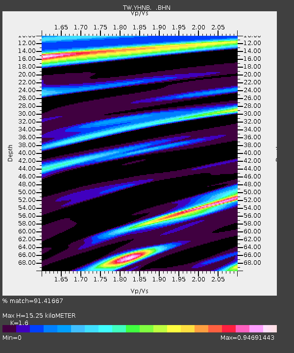
| Estimated Moho Depth: |
15.25 km |
| Estimated Crust Vp/Vs: |
1.60 |
| Assumed Crust Vp: |
6.289 km/s |
| Estimated Crust Vs: |
3.93 km/s |
| Estimated Crust Poisson's Ratio: |
0.18 |
|
| Radial Match: |
91.41667 % |
| Radial Bump: |
400 |
| Transverse Match: |
59.41665 % |
| Transverse Bump: |
400 |
| SOD ConfigId: |
2760 |
| Insert Time: |
2010-03-09 22:16:39.809 +0000 |
| GWidth: |
2.5 |
| Max Bumps: |
400 |
| Tol: |
0.001 |
|

Signal To Noise
| Channel | StoN | STA | LTA |
| TW:YHNB: :BHN:20090418T19:23:53.120002Z | 4.8030176 | 2.2019822E-6 | 4.584581E-7 |
| TW:YHNB: :BHE:20090418T19:23:53.120002Z | 2.7908256 | 1.1163148E-6 | 3.999945E-7 |
| TW:YHNB: :BHZ:20090418T19:23:53.120002Z | 2.700646 | 1.1480015E-6 | 4.2508404E-7 |
| Arrivals |
| Ps | 1.6 SECOND |
| PpPs | 5.8 SECOND |
| PsPs/PpSs | 7.4 SECOND |


