You are here: Home > Network List > IW - Intermountain West Stations List
> Station MOOW Moose Ponds, Wyoming, USA > Earthquake Result Viewer
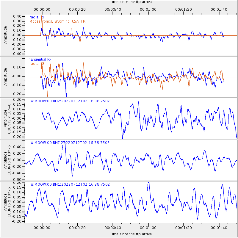
MOOW Moose Ponds, Wyoming, USA - Earthquake Result Viewer
*The percent match for this event was below the threshold and hence no stack was calculated.
| Earthquake location: |
Samoa Islands |
| Earthquake latitude/longitude: |
-15.0/-172.7 |
| Earthquake time(UTC): |
2022/07/12 (193) 02:04:57 GMT |
| Earthquake Depth: |
33 km |
| Earthquake Magnitude: |
6.0 Mi |
| Earthquake Catalog/Contributor: |
NEIC PDE/pt |
|
| Network: |
IW Intermountain West |
| Station: |
MOOW Moose Ponds, Wyoming, USA |
| Lat/Lon: |
43.75 N/110.74 W |
| Elevation: |
2128 m |
|
| Distance: |
81.3 deg |
| Az: |
40.342 deg |
| Baz: |
239.68 deg |
| Ray Param: |
$rayparam |
*The percent match for this event was below the threshold and hence was not used in the summary stack. |
|
| Radial Match: |
63.503082 % |
| Radial Bump: |
400 |
| Transverse Match: |
60.77581 % |
| Transverse Bump: |
400 |
| SOD ConfigId: |
28208852 |
| Insert Time: |
2022-07-26 02:17:21.267 +0000 |
| GWidth: |
2.5 |
| Max Bumps: |
400 |
| Tol: |
0.001 |
|
Signal To Noise
| Channel | StoN | STA | LTA |
| IW:MOOW:00:BHZ:20220712T02:16:38.750Z | 1.1786224 | 7.9075484E-8 | 6.7091456E-8 |
| IW:MOOW:00:BH1:20220712T02:16:38.750Z | 1.4149503 | 8.606365E-8 | 6.0824505E-8 |
| IW:MOOW:00:BH2:20220712T02:16:38.750Z | 1.3929354 | 6.470482E-8 | 4.6452133E-8 |
| Arrivals |
| Ps | |
| PpPs | |
| PsPs/PpSs | |


