You are here: Home > Network List > US - United States National Seismic Network Stations List
> Station HAWA Hanford, Washington, USA > Earthquake Result Viewer
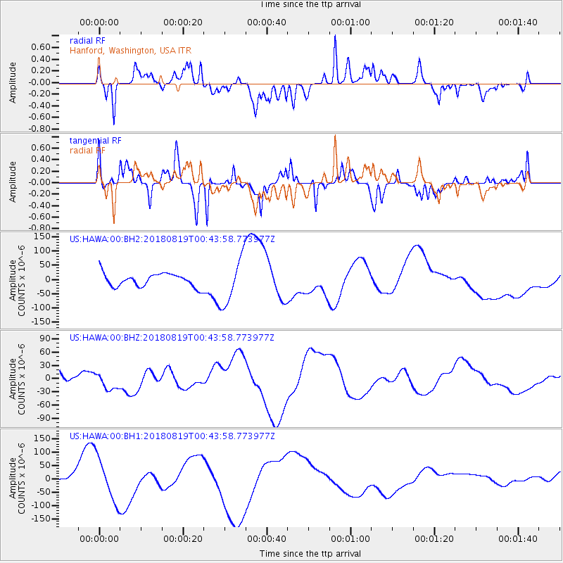
HAWA Hanford, Washington, USA - Earthquake Result Viewer
*The percent match for this event was below the threshold and hence no stack was calculated.
| Earthquake location: |
Fiji Islands Region |
| Earthquake latitude/longitude: |
-17.9/-178.2 |
| Earthquake time(UTC): |
2018/08/19 (231) 00:32:59 GMT |
| Earthquake Depth: |
520 km |
| Earthquake Magnitude: |
5.7 mb |
| Earthquake Catalog/Contributor: |
NEIC PDE/us |
|
| Network: |
US United States National Seismic Network |
| Station: |
HAWA Hanford, Washington, USA |
| Lat/Lon: |
46.39 N/119.53 W |
| Elevation: |
364 m |
|
| Distance: |
83.0 deg |
| Az: |
36.557 deg |
| Baz: |
235.006 deg |
| Ray Param: |
$rayparam |
*The percent match for this event was below the threshold and hence was not used in the summary stack. |
|
| Radial Match: |
62.758427 % |
| Radial Bump: |
400 |
| Transverse Match: |
46.175224 % |
| Transverse Bump: |
303 |
| SOD ConfigId: |
2825771 |
| Insert Time: |
2018-09-02 02:03:53.511 +0000 |
| GWidth: |
2.5 |
| Max Bumps: |
400 |
| Tol: |
0.001 |
|
Signal To Noise
| Channel | StoN | STA | LTA |
| US:HAWA:00:BHZ:20180819T00:43:58.773977Z | 0.86887825 | 1.9956713E-5 | 2.2968365E-5 |
| US:HAWA:00:BH1:20180819T00:43:58.773977Z | 4.069149 | 7.905742E-5 | 1.942849E-5 |
| US:HAWA:00:BH2:20180819T00:43:58.773977Z | 3.5498724 | 8.2006925E-5 | 2.3101371E-5 |
| Arrivals |
| Ps | |
| PpPs | |
| PsPs/PpSs | |


