You are here: Home > Network List > AG - Arkansas Seismic Network Stations List
> Station XB02 XB02 > Earthquake Result Viewer
XB02 XB02 - Earthquake Result Viewer
| Earthquake location: |
Easter Island Region |
| Earthquake latitude/longitude: |
-22.6/-114.2 |
| Earthquake time(UTC): |
2022/07/12 (193) 19:17:00 GMT |
| Earthquake Depth: |
10 km |
| Earthquake Magnitude: |
6.4 mb |
| Earthquake Catalog/Contributor: |
NEIC PDE/us |
|
| Network: |
AG Arkansas Seismic Network |
| Station: |
XB02 XB02 |
| Lat/Lon: |
33.20 N/92.49 W |
| Elevation: |
69 m |
|
| Distance: |
59.2 deg |
| Az: |
21.153 deg |
| Baz: |
203.437 deg |
| Ray Param: |
0.06233209 |
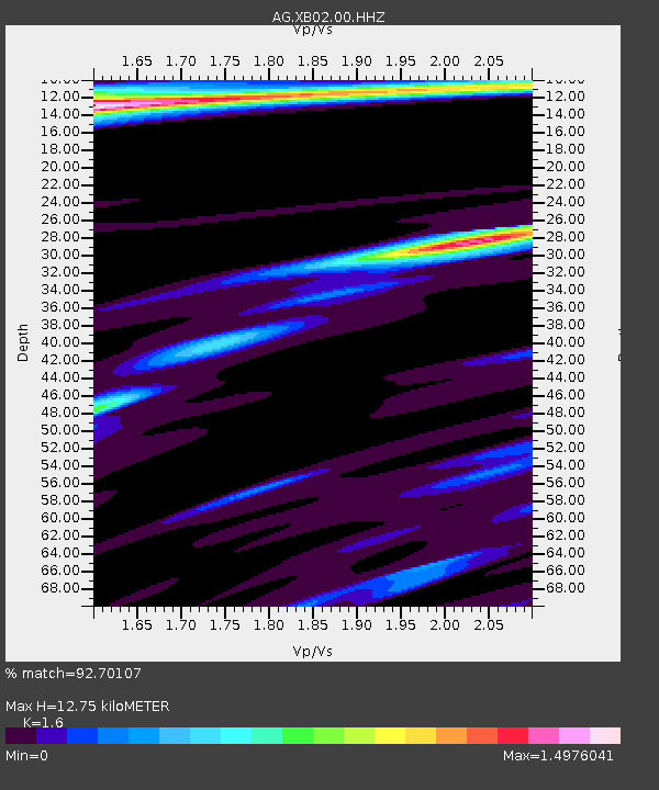
| Estimated Moho Depth: |
12.75 km |
| Estimated Crust Vp/Vs: |
1.60 |
| Assumed Crust Vp: |
6.245 km/s |
| Estimated Crust Vs: |
3.903 km/s |
| Estimated Crust Poisson's Ratio: |
0.18 |
|
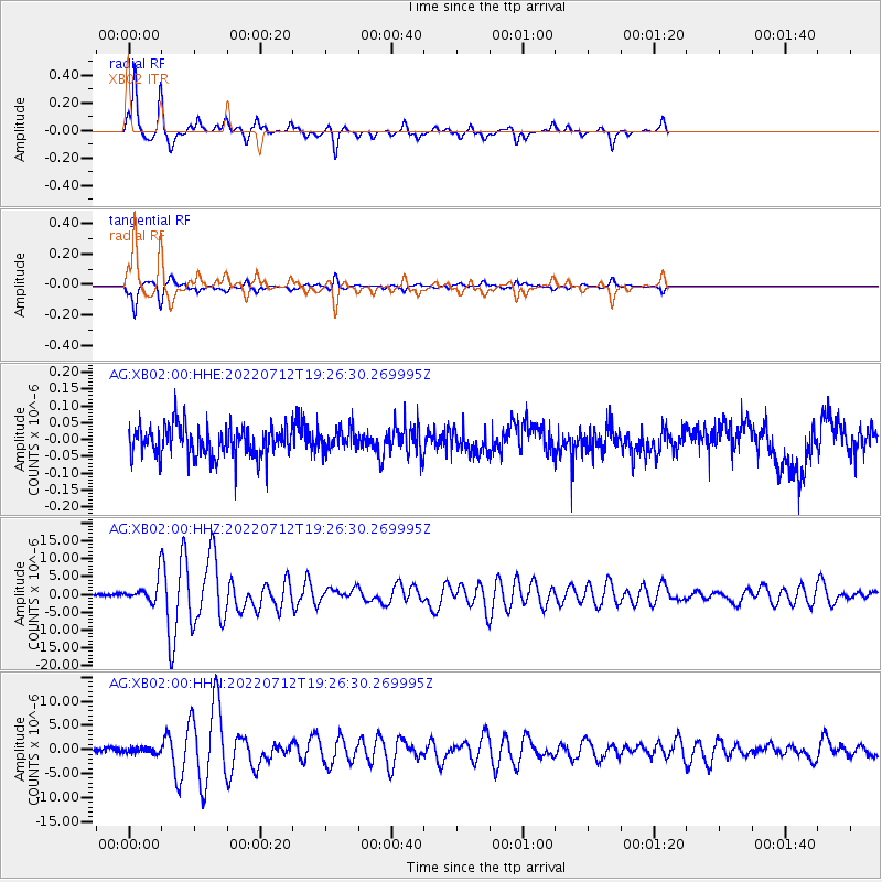
| Radial Match: |
92.70107 % |
| Radial Bump: |
268 |
| Transverse Match: |
92.66402 % |
| Transverse Bump: |
280 |
| SOD ConfigId: |
28208852 |
| Insert Time: |
2022-07-26 19:19:38.456 +0000 |
| GWidth: |
2.5 |
| Max Bumps: |
400 |
| Tol: |
0.001 |
|
Signal To Noise
| Channel | StoN | STA | LTA |
| AG:XB02:00:HHZ:20220712T19:26:30.269995Z | 3.3841043 | 2.9137502E-6 | 8.610108E-7 |
| AG:XB02:00:HHN:20220712T19:26:30.269995Z | 1.1597005 | 6.087992E-7 | 5.2496245E-7 |
| AG:XB02:00:HHE:20220712T19:26:30.269995Z | 0.7010639 | 3.095413E-8 | 4.4153083E-8 |
| Arrivals |
| Ps | 1.3 SECOND |
| PpPs | 5.0 SECOND |
| PsPs/PpSs | 6.3 SECOND |


