You are here: Home > Network List > AK - Alaska Regional Network Stations List
> Station E21K Killik River, AK, USA > Earthquake Result Viewer
E21K Killik River, AK, USA - Earthquake Result Viewer
| Earthquake location: |
Easter Island Region |
| Earthquake latitude/longitude: |
-22.6/-114.2 |
| Earthquake time(UTC): |
2022/07/12 (193) 19:17:00 GMT |
| Earthquake Depth: |
10 km |
| Earthquake Magnitude: |
6.4 mb |
| Earthquake Catalog/Contributor: |
NEIC PDE/us |
|
| Network: |
AK Alaska Regional Network |
| Station: |
E21K Killik River, AK, USA |
| Lat/Lon: |
68.44 N/153.97 W |
| Elevation: |
653 m |
|
| Distance: |
95.3 deg |
| Az: |
346.262 deg |
| Baz: |
143.573 deg |
| Ray Param: |
0.040826354 |
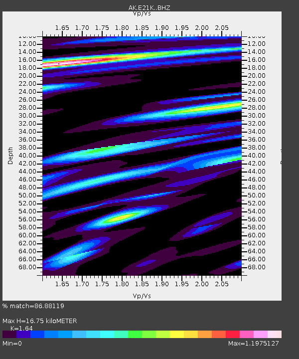
| Estimated Moho Depth: |
16.75 km |
| Estimated Crust Vp/Vs: |
1.64 |
| Assumed Crust Vp: |
6.221 km/s |
| Estimated Crust Vs: |
3.793 km/s |
| Estimated Crust Poisson's Ratio: |
0.20 |
|
| Radial Match: |
86.88119 % |
| Radial Bump: |
400 |
| Transverse Match: |
62.870274 % |
| Transverse Bump: |
400 |
| SOD ConfigId: |
28208852 |
| Insert Time: |
2022-07-26 19:20:43.541 +0000 |
| GWidth: |
2.5 |
| Max Bumps: |
400 |
| Tol: |
0.001 |
|

Signal To Noise
| Channel | StoN | STA | LTA |
| AK:E21K: :BHZ:20220712T19:29:52.459997Z | 8.20779 | 4.5685815E-7 | 5.5661527E-8 |
| AK:E21K: :BHN:20220712T19:29:52.459997Z | 2.6580486 | 9.474419E-8 | 3.5644263E-8 |
| AK:E21K: :BHE:20220712T19:29:52.459997Z | 2.3178291 | 8.355806E-8 | 3.605014E-8 |
| Arrivals |
| Ps | 1.8 SECOND |
| PpPs | 7.0 SECOND |
| PsPs/PpSs | 8.7 SECOND |


