You are here: Home > Network List > AV - Alaska Volcano Observatory Stations List
> Station ETKA Kagalaska Island, Regional Station, Alaska > Earthquake Result Viewer
ETKA Kagalaska Island, Regional Station, Alaska - Earthquake Result Viewer
| Earthquake location: |
Easter Island Region |
| Earthquake latitude/longitude: |
-22.6/-114.2 |
| Earthquake time(UTC): |
2022/07/12 (193) 19:17:00 GMT |
| Earthquake Depth: |
10 km |
| Earthquake Magnitude: |
6.4 mb |
| Earthquake Catalog/Contributor: |
NEIC PDE/us |
|
| Network: |
AV Alaska Volcano Observatory |
| Station: |
ETKA Kagalaska Island, Regional Station, Alaska |
| Lat/Lon: |
51.86 N/176.41 W |
| Elevation: |
290 m |
|
| Distance: |
91.9 deg |
| Az: |
326.707 deg |
| Baz: |
125.117 deg |
| Ray Param: |
0.041548938 |
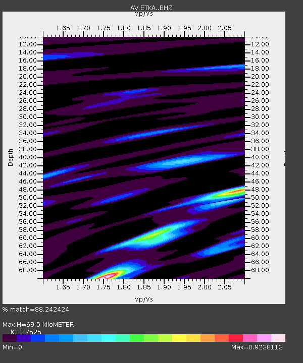
| Estimated Moho Depth: |
69.5 km |
| Estimated Crust Vp/Vs: |
1.75 |
| Assumed Crust Vp: |
5.88 km/s |
| Estimated Crust Vs: |
3.355 km/s |
| Estimated Crust Poisson's Ratio: |
0.26 |
|
| Radial Match: |
88.242424 % |
| Radial Bump: |
258 |
| Transverse Match: |
73.76739 % |
| Transverse Bump: |
393 |
| SOD ConfigId: |
28208852 |
| Insert Time: |
2022-07-26 19:25:11.275 +0000 |
| GWidth: |
2.5 |
| Max Bumps: |
400 |
| Tol: |
0.001 |
|

Signal To Noise
| Channel | StoN | STA | LTA |
| AV:ETKA: :BHZ:20220712T19:29:36.699987Z | 5.3373704 | 6.6152836E-7 | 1.2394275E-7 |
| AV:ETKA: :BHN:20220712T19:29:36.699987Z | 1.4969305 | 1.5858039E-7 | 1.0593704E-7 |
| AV:ETKA: :BHE:20220712T19:29:36.699987Z | 2.1293583 | 2.0368974E-7 | 9.5657796E-8 |
| Arrivals |
| Ps | 9.0 SECOND |
| PpPs | 32 SECOND |
| PsPs/PpSs | 41 SECOND |


