You are here: Home > Network List > AV - Alaska Volcano Observatory Stations List
> Station MAPS Pakushin Southeast, Makushin Volcano, Alaska > Earthquake Result Viewer
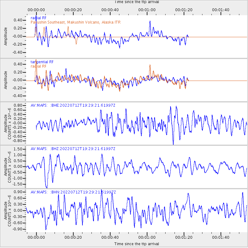
MAPS Pakushin Southeast, Makushin Volcano, Alaska - Earthquake Result Viewer
*The percent match for this event was below the threshold and hence no stack was calculated.
| Earthquake location: |
Easter Island Region |
| Earthquake latitude/longitude: |
-22.6/-114.2 |
| Earthquake time(UTC): |
2022/07/12 (193) 19:17:00 GMT |
| Earthquake Depth: |
10 km |
| Earthquake Magnitude: |
6.4 mb |
| Earthquake Catalog/Contributor: |
NEIC PDE/us |
|
| Network: |
AV Alaska Volcano Observatory |
| Station: |
MAPS Pakushin Southeast, Makushin Volcano, Alaska |
| Lat/Lon: |
53.81 N/166.94 W |
| Elevation: |
333 m |
|
| Distance: |
88.6 deg |
| Az: |
331.823 deg |
| Baz: |
132.628 deg |
| Ray Param: |
$rayparam |
*The percent match for this event was below the threshold and hence was not used in the summary stack. |
|
| Radial Match: |
68.43409 % |
| Radial Bump: |
400 |
| Transverse Match: |
69.9457 % |
| Transverse Bump: |
400 |
| SOD ConfigId: |
28208852 |
| Insert Time: |
2022-07-26 19:26:12.753 +0000 |
| GWidth: |
2.5 |
| Max Bumps: |
400 |
| Tol: |
0.001 |
|
Signal To Noise
| Channel | StoN | STA | LTA |
| AV:MAPS: :BHZ:20220712T19:29:21.61997Z | 4.3070908 | 4.370228E-7 | 1.0146589E-7 |
| AV:MAPS: :BHN:20220712T19:29:21.61997Z | 1.3856419 | 2.0020853E-7 | 1.4448793E-7 |
| AV:MAPS: :BHE:20220712T19:29:21.61997Z | 1.4892815 | 2.1066006E-7 | 1.414508E-7 |
| Arrivals |
| Ps | |
| PpPs | |
| PsPs/PpSs | |


