You are here: Home > Network List > C0 - Colorado Geological Survey Seismic Network Stations List
> Station CHIL CSU-CHILL Radar > Earthquake Result Viewer
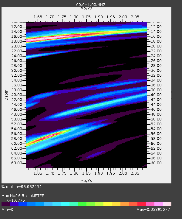
CHIL CSU-CHILL Radar - Earthquake Result Viewer
| Earthquake location: |
Easter Island Region |
| Earthquake latitude/longitude: |
-22.6/-114.2 |
| Earthquake time(UTC): |
2022/07/12 (193) 19:17:00 GMT |
| Earthquake Depth: |
10 km |
| Earthquake Magnitude: |
6.4 mb |
| Earthquake Catalog/Contributor: |
NEIC PDE/us |
|
| Network: |
C0 Colorado Geological Survey Seismic Network |
| Station: |
CHIL CSU-CHILL Radar |
| Lat/Lon: |
40.45 N/104.64 W |
| Elevation: |
1424 m |
|
| Distance: |
63.4 deg |
| Az: |
8.15 deg |
| Baz: |
189.885 deg |
| Ray Param: |
0.05963914 |
| Estimated Moho Depth: |
16.5 km |
| Estimated Crust Vp/Vs: |
1.68 |
| Assumed Crust Vp: |
6.306 km/s |
| Estimated Crust Vs: |
3.759 km/s |
| Estimated Crust Poisson's Ratio: |
0.22 |
|
| Radial Match: |
93.932434 % |
| Radial Bump: |
368 |
| Transverse Match: |
85.88428 % |
| Transverse Bump: |
400 |
| SOD ConfigId: |
28208852 |
| Insert Time: |
2022-07-26 19:29:19.270 +0000 |
| GWidth: |
2.5 |
| Max Bumps: |
400 |
| Tol: |
0.001 |
|

Signal To Noise
| Channel | StoN | STA | LTA |
| C0:CHIL:00:HHZ:20220712T19:26:58.134008Z | 15.732703 | 1.3910735E-6 | 8.841923E-8 |
| C0:CHIL:00:HHN:20220712T19:26:58.134008Z | 1.8758624 | 2.721709E-7 | 1.4509108E-7 |
| C0:CHIL:00:HHE:20220712T19:26:58.134008Z | 0.97948223 | 1.3586049E-7 | 1.3870644E-7 |
| Arrivals |
| Ps | 1.9 SECOND |
| PpPs | 6.7 SECOND |
| PsPs/PpSs | 8.6 SECOND |


