You are here: Home > Network List > C0 - Colorado Geological Survey Seismic Network Stations List
> Station T25A Trinidad, CO > Earthquake Result Viewer
T25A Trinidad, CO - Earthquake Result Viewer
| Earthquake location: |
Easter Island Region |
| Earthquake latitude/longitude: |
-22.6/-114.2 |
| Earthquake time(UTC): |
2022/07/12 (193) 19:17:00 GMT |
| Earthquake Depth: |
10 km |
| Earthquake Magnitude: |
6.4 mb |
| Earthquake Catalog/Contributor: |
NEIC PDE/us |
|
| Network: |
C0 Colorado Geological Survey Seismic Network |
| Station: |
T25A Trinidad, CO |
| Lat/Lon: |
37.08 N/104.25 W |
| Elevation: |
1800 m |
|
| Distance: |
60.1 deg |
| Az: |
9.17 deg |
| Baz: |
190.612 deg |
| Ray Param: |
0.06174505 |
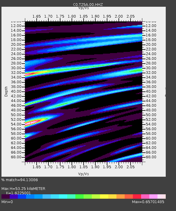
| Estimated Moho Depth: |
53.25 km |
| Estimated Crust Vp/Vs: |
1.62 |
| Assumed Crust Vp: |
6.316 km/s |
| Estimated Crust Vs: |
3.892 km/s |
| Estimated Crust Poisson's Ratio: |
0.19 |
|
| Radial Match: |
94.13086 % |
| Radial Bump: |
256 |
| Transverse Match: |
90.999664 % |
| Transverse Bump: |
400 |
| SOD ConfigId: |
28208852 |
| Insert Time: |
2022-07-26 19:29:25.364 +0000 |
| GWidth: |
2.5 |
| Max Bumps: |
400 |
| Tol: |
0.001 |
|

Signal To Noise
| Channel | StoN | STA | LTA |
| C0:T25A:00:HHZ:20220712T19:26:36.480017Z | 14.522993 | 9.0006836E-7 | 6.1975406E-8 |
| C0:T25A:00:HHN:20220712T19:26:36.480017Z | 3.7174387 | 3.5511331E-7 | 9.552634E-8 |
| C0:T25A:00:HHE:20220712T19:26:36.480017Z | 1.059577 | 6.6524215E-8 | 6.2783755E-8 |
| Arrivals |
| Ps | 5.5 SECOND |
| PpPs | 21 SECOND |
| PsPs/PpSs | 27 SECOND |


