You are here: Home > Network List > IU - Global Seismograph Network (GSN - IRIS/USGS) Stations List
> Station JOHN Johnston Island, USA > Earthquake Result Viewer
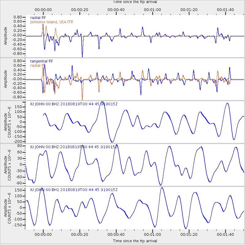
JOHN Johnston Island, USA - Earthquake Result Viewer
*The percent match for this event was below the threshold and hence no stack was calculated.
| Earthquake location: |
Fiji Islands Region |
| Earthquake latitude/longitude: |
-17.9/-178.0 |
| Earthquake time(UTC): |
2018/08/19 (231) 00:39:07 GMT |
| Earthquake Depth: |
576 km |
| Earthquake Magnitude: |
5.7 mb |
| Earthquake Catalog/Contributor: |
NEIC PDE/us |
|
| Network: |
IU Global Seismograph Network (GSN - IRIS/USGS) |
| Station: |
JOHN Johnston Island, USA |
| Lat/Lon: |
16.73 N/169.53 W |
| Elevation: |
2.0 m |
|
| Distance: |
35.4 deg |
| Az: |
14.073 deg |
| Baz: |
193.982 deg |
| Ray Param: |
$rayparam |
*The percent match for this event was below the threshold and hence was not used in the summary stack. |
|
| Radial Match: |
73.19167 % |
| Radial Bump: |
369 |
| Transverse Match: |
62.45147 % |
| Transverse Bump: |
395 |
| SOD ConfigId: |
2825771 |
| Insert Time: |
2018-09-02 02:06:34.693 +0000 |
| GWidth: |
2.5 |
| Max Bumps: |
400 |
| Tol: |
0.001 |
|
Signal To Noise
| Channel | StoN | STA | LTA |
| IU:JOHN:00:BHZ:20180819T00:44:45.919015Z | 0.9977141 | 5.2838906E-5 | 5.2959967E-5 |
| IU:JOHN:00:BH1:20180819T00:44:45.919015Z | 2.1472502 | 1.2143689E-4 | 5.6554607E-5 |
| IU:JOHN:00:BH2:20180819T00:44:45.919015Z | 3.0171058 | 1.5327852E-4 | 5.0803166E-5 |
| Arrivals |
| Ps | |
| PpPs | |
| PsPs/PpSs | |


