You are here: Home > Network List > CI - Caltech Regional Seismic Network Stations List
> Station LRL Laurel Mtn Radio Fac, Ridgecrest, CA, USA > Earthquake Result Viewer
LRL Laurel Mtn Radio Fac, Ridgecrest, CA, USA - Earthquake Result Viewer
| Earthquake location: |
Easter Island Region |
| Earthquake latitude/longitude: |
-22.6/-114.2 |
| Earthquake time(UTC): |
2022/07/12 (193) 19:17:00 GMT |
| Earthquake Depth: |
10 km |
| Earthquake Magnitude: |
6.4 mb |
| Earthquake Catalog/Contributor: |
NEIC PDE/us |
|
| Network: |
CI Caltech Regional Seismic Network |
| Station: |
LRL Laurel Mtn Radio Fac, Ridgecrest, CA, USA |
| Lat/Lon: |
35.48 N/117.68 W |
| Elevation: |
1340 m |
|
| Distance: |
57.9 deg |
| Az: |
356.639 deg |
| Baz: |
176.194 deg |
| Ray Param: |
0.06322537 |
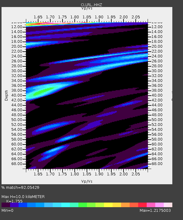
| Estimated Moho Depth: |
10.0 km |
| Estimated Crust Vp/Vs: |
1.75 |
| Assumed Crust Vp: |
6.276 km/s |
| Estimated Crust Vs: |
3.576 km/s |
| Estimated Crust Poisson's Ratio: |
0.26 |
|
| Radial Match: |
92.05429 % |
| Radial Bump: |
321 |
| Transverse Match: |
93.65338 % |
| Transverse Bump: |
400 |
| SOD ConfigId: |
28208852 |
| Insert Time: |
2022-07-26 19:33:20.256 +0000 |
| GWidth: |
2.5 |
| Max Bumps: |
400 |
| Tol: |
0.001 |
|
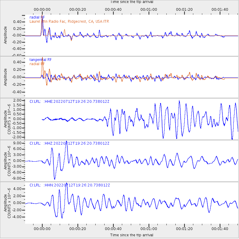
Signal To Noise
| Channel | StoN | STA | LTA |
| CI:LRL: :HHZ:20220712T19:26:20.738012Z | 8.627817 | 8.6071844E-7 | 9.9760854E-8 |
| CI:LRL: :HHN:20220712T19:26:20.738012Z | 5.748001 | 3.5526907E-7 | 6.180741E-8 |
| CI:LRL: :HHE:20220712T19:26:20.738012Z | 1.0363314 | 9.320388E-8 | 8.993637E-8 |
| Arrivals |
| Ps | 1.3 SECOND |
| PpPs | 4.2 SECOND |
| PsPs/PpSs | 5.4 SECOND |


