You are here: Home > Network List > CN - Canadian National Seismograph Network Stations List
> Station PABB Port Alberni, BC, CA > Earthquake Result Viewer
PABB Port Alberni, BC, CA - Earthquake Result Viewer
| Earthquake location: |
Easter Island Region |
| Earthquake latitude/longitude: |
-22.6/-114.2 |
| Earthquake time(UTC): |
2022/07/12 (193) 19:17:00 GMT |
| Earthquake Depth: |
10 km |
| Earthquake Magnitude: |
6.4 mb |
| Earthquake Catalog/Contributor: |
NEIC PDE/us |
|
| Network: |
CN Canadian National Seismograph Network |
| Station: |
PABB Port Alberni, BC, CA |
| Lat/Lon: |
49.22 N/124.81 W |
| Elevation: |
3.0 m |
|
| Distance: |
72.1 deg |
| Az: |
352.708 deg |
| Baz: |
169.695 deg |
| Ray Param: |
0.053880475 |
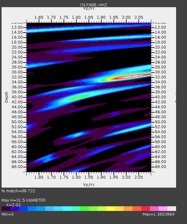
| Estimated Moho Depth: |
31.5 km |
| Estimated Crust Vp/Vs: |
2.02 |
| Assumed Crust Vp: |
6.391 km/s |
| Estimated Crust Vs: |
3.164 km/s |
| Estimated Crust Poisson's Ratio: |
0.34 |
|
| Radial Match: |
89.722 % |
| Radial Bump: |
384 |
| Transverse Match: |
90.72446 % |
| Transverse Bump: |
400 |
| SOD ConfigId: |
28208852 |
| Insert Time: |
2022-07-26 19:36:29.997 +0000 |
| GWidth: |
2.5 |
| Max Bumps: |
400 |
| Tol: |
0.001 |
|

Signal To Noise
| Channel | StoN | STA | LTA |
| CN:PABB: :HHZ:20220712T19:27:53.290014Z | 2.8564222 | 6.360565E-7 | 2.2267594E-7 |
| CN:PABB: :HHN:20220712T19:27:53.290014Z | 2.8066819 | 3.0064754E-7 | 1.07118495E-7 |
| CN:PABB: :HHE:20220712T19:27:53.290014Z | 0.79696155 | 1.4764784E-7 | 1.8526343E-7 |
| Arrivals |
| Ps | 5.2 SECOND |
| PpPs | 14 SECOND |
| PsPs/PpSs | 20 SECOND |


